Monte Romano elevation
Monte Romano (Latium, Provincia di Viterbo), Italy elevation is 229 meters and Monte Romano elevation in feet is 751 ft above sea level [src 1]. Monte Romano is a seat of a third-order administrative division (feature code) with elevation that is 93 meters (305 ft) smaller than average city elevation in Italy.
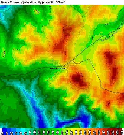
Below is the Elevation map of Monte Romano, which displays elevation range with different colors. Scale of the first map is from 34 to 368 m (112 to 1207 ft) with average elevation of 201 meters (=659 ft) [note 1]
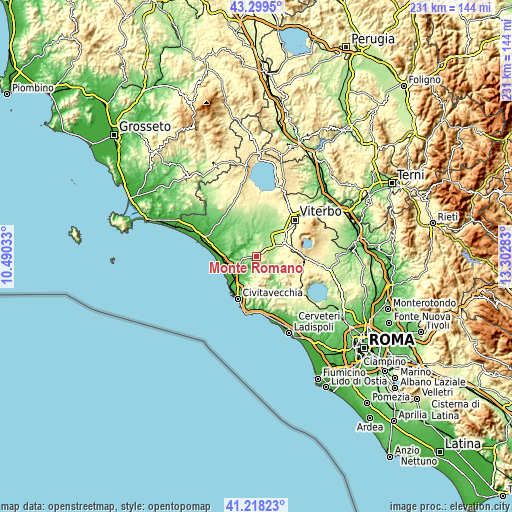
These maps also provides idea of topography and contour of this city, they are displayed at different zoom levels. More info about maps, scale and edge coordinates you can find below images.
| \ | Map #1 | Topo.Map |
| Scale [m] | 34..368 m | × |
| Scale [ft] | 112..1207 ft | × |
| Average | 201 m = 659 ft | × |
| Width | 7.23 km = 4.5 mi | 231.4 km = 143.8 mi |
| Height | 7.23 km = 4.5 mi | 231.4 km = 143.8 mi |
| ↑Max Latitude | 42.299962° | 43.2995° |
| Latitude at center | 42.26745° | 42.26745° |
| ↓Min Latitude | 42.234921° | 41.21823° |
| ← Min Longitude | 11.852635° | 10.49033° |
| Longitude center | 11.89658° | 11.89658° |
| →Max Longitude | 11.940525° | 13.30283° |
Nearby cities:
Cities around Monte Romano sort by population:
• Civitavecchia elevation 22 m
21 km,  203°
203°
• Tarquinia 128 m
11.6 km,  262°
262°
• Vetralla 364 m
15.6 km,  68°
68°
• Tuscania 189 m
17 km,  352°
352°
• Tolfa 509 m
13.4 km,  167°
167°
• Allumiere 522 m
12.2 km,  177°
177°
• Blera 287 m
11 km,  86°
86°
• San Martino al Cimino 526 m
22 km,  58°
58°
• Vejano 399 m
17.1 km,  108°
108°
• Villa San Giovanni in Tuscia 333 m
13 km,  84°
84°
• Aurelia 65 m
16.9 km,  212°
212°
• Barbarano Romano 341 m
14.2 km,  98°
98°
Multilingual:
 En español:
Monte Romano elevación 229 m.
 En France:
Monte Romano élévation 229 m.
 Auf Deutsch:
Monte Romano höhe über dem Meeresspiegel ist 229 m.

Sources and notes:
- [note 1] Map square and city borders are not equal. Map elevation data is calculated only from area inside that square.
- [src 1] Elevation data from geonames database provided with same terms of usage.
- [src 2] The elevation map of Monte Romano is generated using elevation data from NASA's 3 arcsec (90m) resolution SRTM data.
- [src 3] Base (background) map © OpenStreetMap contributors tiles are generated by Geofabrik and OpenTopoMap.
Copyright & License:
This Monte Romano Elevation Map is licensed under CC BY-SA. You may reuse any part from this page, if you give a proper credit by linking to this URL:
 More info on terms of use page.