Azeglio elevation
Azeglio (Piedmont, Torino), Italy elevation is 239 meters and Azeglio elevation in feet is 784 ft above sea level [src 1]. Azeglio is a seat of a third-order administrative division (feature code) with elevation that is 83 meters (272 ft) smaller than average city elevation in Italy.
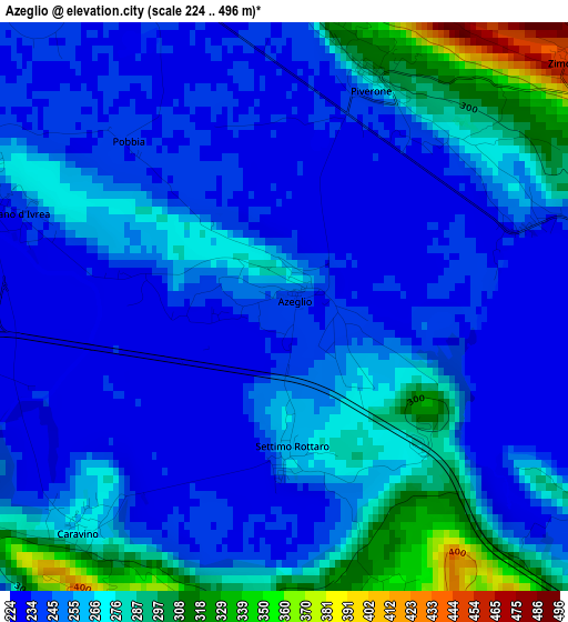
Below is the Elevation map of Azeglio, which displays elevation range with different colors. Scale of the first map is from 224 to 496 m (735 to 1627 ft) with average elevation of 257.1 meters (=844 ft) [note 1]
These maps also provides idea of topography and contour of this city, they are displayed at different zoom levels. More info about maps, scale and edge coordinates you can find below images.
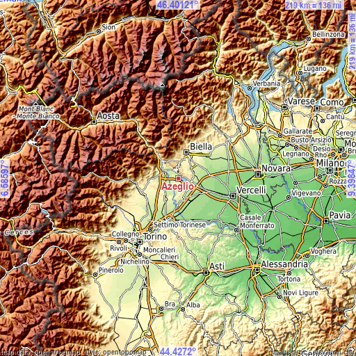
| \ | Map #1 | Topo.Map |
| Scale [m] | 224..496 m | × |
| Scale [ft] | 735..1627 ft | × |
| Average | 257.1 m = 844 ft | × |
| Width | 6.86 km = 4.3 mi | 219.5 km = 136.4 mi |
| Height | 6.86 km = 4.3 mi | 219.5 km = 136.4 mi |
| ↑Max Latitude | 45.453665° | 46.40121° |
| Latitude at center | 45.42283° | 45.42283° |
| ↓Min Latitude | 45.391978° | 44.4272° |
| ← Min Longitude | 7.948275° | 6.58597° |
| Longitude center | 7.99222° | 7.99222° |
| →Max Longitude | 8.036165° | 9.39847° |
Nearby cities:
Cities around Azeglio sort by population:
• Albiano d'Ivrea elevation 234 m
3.7 km,  290°
290°
• Bollengo 252 m
6.7 km,  323°
323°
• Viverone 282 m
4.5 km,  83°
83°
• Caravino 264 m
3.6 km,  223°
223°
• Piverone 284 m
2.8 km,  25°
25°
• Palazzo Canavese 246 m
4.2 km,  344°
344°
• Vestignè 237 m
5 km, 216°
• Roppolo 312 m
6.1 km,  92°
92°
• Settimo Rottaro 260 m
1.7 km,  176°
176°
• Zimone 445 m
4.6 km,  50°
50°
• Cossano Canavese 349 m
3.9 km, 180°
• Magnano 538 m
4.6 km,  10°
10°
Multilingual:
 En español:
Azeglio elevación 239 m.
 En France:
Azeglio élévation 239 m.


Sources and notes:
- [note 1] Map square and city borders are not equal. Map elevation data is calculated only from area inside that square.
- [src 1] Elevation data from geonames database provided with same terms of usage.
- [src 2] The elevation map of Azeglio is generated using elevation data from NASA's 3 arcsec (90m) resolution SRTM data.
- [src 3] Base (background) map © OpenStreetMap contributors tiles are generated by Geofabrik and OpenTopoMap.
Copyright & License:
This Azeglio Elevation Map is licensed under CC BY-SA. You may reuse any part from this page, if you give a proper credit by linking to this URL:
 More info on terms of use page.