Barletta elevation
Barletta (Apulia, Provincia di Barletta - Andria - Trani), Italy elevation is 19 meters and Barletta elevation in feet is 62 ft above sea level [src 1]. Barletta is a seat of a second-order administrative division (feature code) with elevation that is 303 meters (994 ft) smaller than average city elevation in Italy.
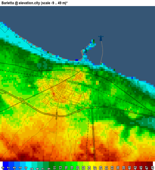
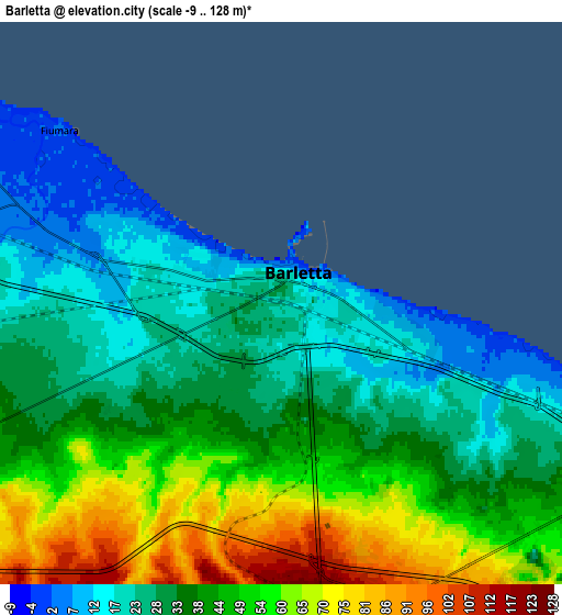
Below is the Elevation map of Barletta, which displays elevation range with different colors. Scale of the first map is from -9 to 49 m (-30 to 161 ft) with average elevation of 21.9 meters (=72 ft) [note 1]
These maps also provides idea of topography and contour of this city, they are displayed at different zoom levels. More info about maps, scale and edge coordinates you can find below images.
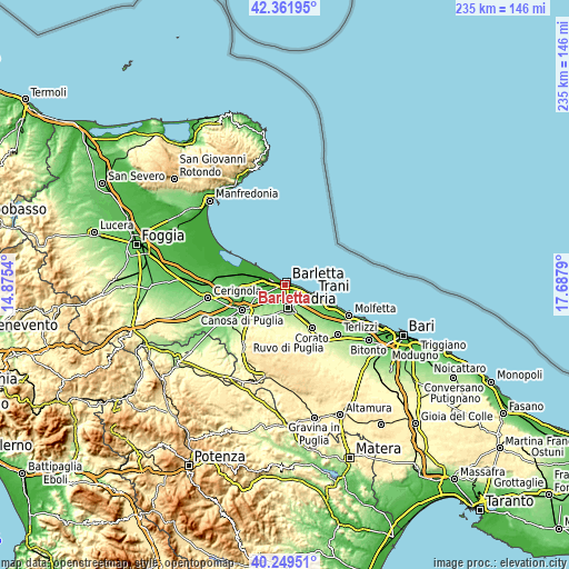
| \ | Map #1 | Map #2 | Topo.Map |
| Scale [m] | -9..49 m | -9..128 m | × |
| Scale [ft] | -30..161 ft | -30..420 ft | × |
| Average | 21.9 m = 72 ft | 40 m = 131 ft | × |
| Width | 7.34 km = 4.6 mi | 14.68 km = 9.1 mi | 234.9 km = 146 mi |
| Height | 7.34 km = 4.6 mi | 14.68 km = 9.1 mi | 234.9 km = 146 mi |
| ↑Max Latitude | 41.347289° | 41.380271° | 42.36195° |
| Latitude at center | 41.31429° | 41.31429° | 41.31429° |
| ↓Min Latitude | 41.281274° | 41.248242° | 40.24951° |
| ← Min Longitude | 16.237705° | 16.193759° | 14.8754° |
| Longitude center | 16.28165° | 16.28165° | 16.28165° |
| →Max Longitude | 16.325595° | 16.369541° | 17.6879° |
Nearby cities:
Cities around Barletta sort by population:
• Andria elevation 157 m
9.3 km,  171°
171°
• Molfetta 27 m
29.4 km,  115°
115°
• Trani 13 m
11.5 km,  110°
110°
• Bisceglie 20 m
20 km, 113°
• Corato 236 m
21.1 km,  149°
149°
• Canosa di Puglia 131 m
20.8 km,  239°
239°
• Terlizzi 196 m
30.2 km,  133°
133°
• Ruvo di Puglia 259 m
27.7 km,  142°
142°
• Trinitapoli 9 m
16.7 km,  286°
286°
• San Ferdinando di Puglia 67 m
17.7 km,  265°
265°
• Margherita di Savoia 2 m
12.5 km,  300°
300°
• Capirro 35 m
13.5 km, 119°
Multilingual:
 En español:
Barletta elevación 19 m.
 En France:
Barletta élévation 19 m.


Sources and notes:
- [note 1] Map square and city borders are not equal. Map elevation data is calculated only from area inside that square.
- [src 1] Elevation data from geonames database provided with same terms of usage.
- [src 2] The elevation map of Barletta is generated using elevation data from NASA's 3 arcsec (90m) resolution SRTM data.
- [src 3] Base (background) map © OpenStreetMap contributors tiles are generated by Geofabrik and OpenTopoMap.
Copyright & License:
This Barletta Elevation Map is licensed under CC BY-SA. You may reuse any part from this page, if you give a proper credit by linking to this URL:
 More info on terms of use page.