Corato elevation
Corato (Apulia, Bari), Italy elevation is 236 meters and Corato elevation in feet is 774 ft above sea level [src 1]. Corato is a seat of a third-order administrative division (feature code) with elevation that is 86 meters (282 ft) smaller than average city elevation in Italy.
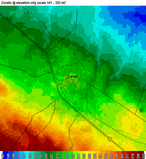
Below is the Elevation map of Corato, which displays elevation range with different colors. Scale of the first map is from 141 to 333 m (463 to 1093 ft) with average elevation of 225 meters (=738 ft) [note 1]
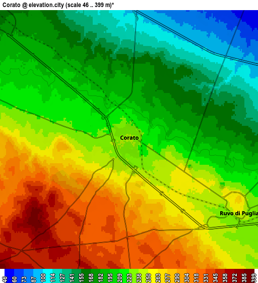
These maps also provides idea of topography and contour of this city, they are displayed at different zoom levels. More info about maps, scale and edge coordinates you can find below images.
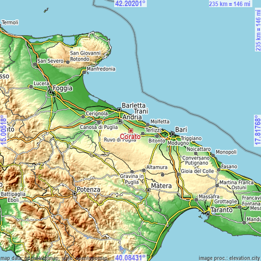
| \ | Map #1 | Map #2 | Topo.Map |
| Scale [m] | 141..333 m | 46..399 m | × |
| Scale [ft] | 463..1093 ft | 151..1309 ft | × |
| Average | 225 m = 738 ft | 224 m = 735 ft | × |
| Width | 7.36 km = 4.6 mi | 14.72 km = 9.1 mi | 235.5 km = 146.3 mi |
| Height | 7.36 km = 4.6 mi | 14.72 km = 9.1 mi | 235.5 km = 146.3 mi |
| ↑Max Latitude | 41.184791° | 41.217856° | 42.20201° |
| Latitude at center | 41.15171° | 41.15171° | 41.15171° |
| ↓Min Latitude | 41.118612° | 41.085498° | 40.08431° |
| ← Min Longitude | 16.367485° | 16.323539° | 15.00518° |
| Longitude center | 16.41143° | 16.41143° | 16.41143° |
| →Max Longitude | 16.455375° | 16.499321° | 17.81768° |
Nearby cities:
Cities around Corato sort by population:
• Andria elevation 157 m
13 km,  312°
312°
• Barletta 19 m
21.1 km,  329°
329°
• Molfetta 27 m
16.6 km,  70°
70°
• Trani 13 m
14 km,  359°
359°
• Bisceglie 20 m
12.6 km,  36°
36°
• Bitonto 117 m
23.9 km,  101°
101°
• Terlizzi 196 m
11.5 km, 102°
• Ruvo di Puglia 259 m
7.2 km,  121°
121°
• Giovinazzo 17 m
22 km,  80°
80°
• Palombaio 199 m
18.9 km, 118°
• Mariotto 241 m
16.9 km,  131°
131°
• Capirro 35 m
11.4 km,  4°
4°
Multilingual:
 En español:
Corato elevación 236 m.
 En France:
Corato élévation 236 m.


Sources and notes:
- [note 1] Map square and city borders are not equal. Map elevation data is calculated only from area inside that square.
- [src 1] Elevation data from geonames database provided with same terms of usage.
- [src 2] The elevation map of Corato is generated using elevation data from NASA's 3 arcsec (90m) resolution SRTM data.
- [src 3] Base (background) map © OpenStreetMap contributors tiles are generated by Geofabrik and OpenTopoMap.
Copyright & License:
This Corato Elevation Map is licensed under CC BY-SA. You may reuse any part from this page, if you give a proper credit by linking to this URL:
 More info on terms of use page.