Biandronno elevation
Biandronno (Lombardy, Provincia di Varese), Italy elevation is 267 meters and Biandronno elevation in feet is 876 ft above sea level [src 1]. Biandronno is a seat of a third-order administrative division (feature code) with elevation that is 55 meters (180 ft) smaller than average city elevation in Italy.
Below is the Elevation map of Biandronno, which displays elevation range with different colors. Scale of the first map is from 217 to 437 m (712 to 1434 ft) with average elevation of 258.3 meters (=847 ft) [note 1]
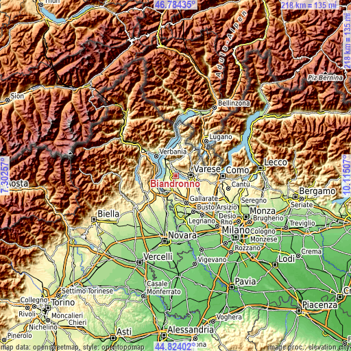
These maps also provides idea of topography and contour of this city, they are displayed at different zoom levels. More info about maps, scale and edge coordinates you can find below images.
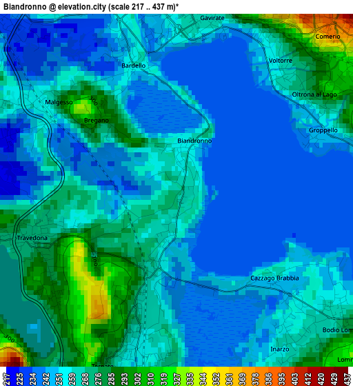
| \ | Map #1 | Topo.Map |
| Scale [m] | 217..437 m | × |
| Scale [ft] | 712..1434 ft | × |
| Average | 258.3 m = 847 ft | × |
| Width | 6.81 km = 4.2 mi | 218 km = 135.5 mi |
| Height | 6.81 km = 4.2 mi | 218 km = 135.5 mi |
| ↑Max Latitude | 45.843432° | 46.78435° |
| Latitude at center | 45.81281° | 45.81281° |
| ↓Min Latitude | 45.782171° | 44.82402° |
| ← Min Longitude | 8.664875° | 7.30257° |
| Longitude center | 8.70882° | 8.70882° |
| →Max Longitude | 8.752765° | 10.11507° |
Nearby cities:
Cities around Biandronno sort by population:
• Gavirate elevation 242 m
3 km,  26°
26°
• Travedona Monate 272 m
3 km,  251°
251°
• Varano Borghi 277 m
4.3 km,  184°
184°
• Comerio 390 m
4.1 km,  38°
38°
• Ternate 259 m
3 km,  194°
194°
• Bodio 280 m
4.2 km,  127°
127°
• Bodio Lomnago 278 m
4.2 km, 129°
• Bardello 251 m
2.7 km,  340°
340°
• Inarzo 262 m
3.7 km,  145°
145°
• Malgesso 255 m
3.1 km,  302°
302°
• Bregano 320 m
2.2 km,  311°
311°
• Cazzago Brabbia 247 m
2.8 km, 133°
Multilingual:
 En español:
Biandronno elevación 267 m.
 En France:
Biandronno élévation 267 m.
 Auf Deutsch:
Biandronno höhe über dem Meeresspiegel ist 267 m.

Sources and notes:
- [note 1] Map square and city borders are not equal. Map elevation data is calculated only from area inside that square.
- [src 1] Elevation data from geonames database provided with same terms of usage.
- [src 2] The elevation map of Biandronno is generated using elevation data from NASA's 3 arcsec (90m) resolution SRTM data.
- [src 3] Base (background) map © OpenStreetMap contributors tiles are generated by Geofabrik and OpenTopoMap.
Copyright & License:
This Biandronno Elevation Map is licensed under CC BY-SA. You may reuse any part from this page, if you give a proper credit by linking to this URL:
 More info on terms of use page.