Bobbio Pellice elevation
Bobbio Pellice (Piedmont, Torino), Italy elevation is 747 meters and Bobbio Pellice elevation in feet is 2451 ft above sea level [src 1]. Bobbio Pellice is a seat of a third-order administrative division (feature code) with elevation that is 425 meters (1394 ft) bigger than average city elevation in Italy.
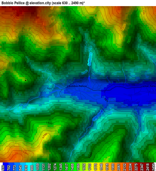
Below is the Elevation map of Bobbio Pellice, which displays elevation range with different colors. Scale of the first map is from 630 to 2490 m (2067 to 8169 ft) with average elevation of 1284.5 meters (=4214 ft) [note 1]
These maps also provides idea of topography and contour of this city, they are displayed at different zoom levels. More info about maps, scale and edge coordinates you can find below images.
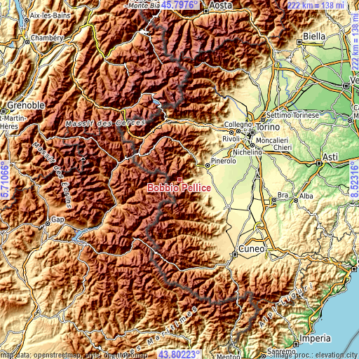
| \ | Map #1 | Topo.Map |
| Scale [m] | 630..2490 m | × |
| Scale [ft] | 2067..8169 ft | × |
| Average | 1284.5 m = 4214 ft | × |
| Width | 6.93 km = 4.3 mi | 221.9 km = 137.9 mi |
| Height | 6.93 km = 4.3 mi | 221.9 km = 137.9 mi |
| ↑Max Latitude | 44.839709° | 45.7976° |
| Latitude at center | 44.80854° | 44.80854° |
| ↓Min Latitude | 44.777354° | 43.80223° |
| ← Min Longitude | 7.072965° | 5.71066° |
| Longitude center | 7.11691° | 7.11691° |
| →Max Longitude | 7.160855° | 8.52316° |
Nearby cities:
Cities around Bobbio Pellice sort by population:
• Airali elevation 472 m
10.7 km,  85°
85°
• Torre Pellice 539 m
8 km,  80°
80°
• Bibiana 415 m
13.6 km, 94°
• Prarostino 747 m
13.5 km,  61°
61°
• Luserna 499 m
10.2 km, 90°
• Villar Pellice 676 m
3.4 km, 89°
• Lusernetta 502 m
10.3 km, 93°
• Prali 1474 m
10.4 km,  330°
330°
• Pramollo 1071 m
12.5 km,  27°
27°
• Crissolo 1343 m
12.5 km,  165°
165°
• Rorà 954 m
6.7 km,  105°
105°
• Angrogna 758 m
9.3 km,  65°
65°
Multilingual:
 En español:
Bobbio Pellice elevación 747 m.
 En France:
Bobbio Pellice élévation 747 m.
 Auf Deutsch:
Bobbio Pellice höhe über dem Meeresspiegel ist 747 m.

Sources and notes:
- [note 1] Map square and city borders are not equal. Map elevation data is calculated only from area inside that square.
- [src 1] Elevation data from geonames database provided with same terms of usage.
- [src 2] The elevation map of Bobbio Pellice is generated using elevation data from NASA's 3 arcsec (90m) resolution SRTM data.
- [src 3] Base (background) map © OpenStreetMap contributors tiles are generated by Geofabrik and OpenTopoMap.
Copyright & License:
This Bobbio Pellice Elevation Map is licensed under CC BY-SA. You may reuse any part from this page, if you give a proper credit by linking to this URL:
 More info on terms of use page.