Bojano elevation
Bojano (Molise, Provincia di Campobasso), Italy elevation is 485 meters and Bojano elevation in feet is 1591 ft above sea level [src 1]. Bojano is a seat of a third-order administrative division (feature code) with elevation that is 163 meters (535 ft) bigger than average city elevation in Italy.
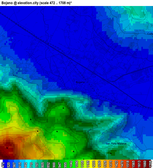
Below is the Elevation map of Bojano, which displays elevation range with different colors. Scale of the first map is from 472 to 1708 m (1549 to 5604 ft) with average elevation of 675.5 meters (=2216 ft) [note 1]
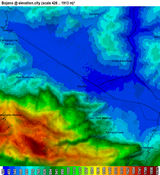
These maps also provides idea of topography and contour of this city, they are displayed at different zoom levels. More info about maps, scale and edge coordinates you can find below images.
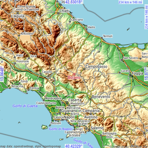
| \ | Map #1 | Map #2 | Topo.Map |
| Scale [m] | 472..1708 m | 426..1913 m | × |
| Scale [ft] | 1549..5604 ft | 1398..6276 ft | × |
| Average | 675.5 m = 2216 ft | 801.2 m = 2629 ft | × |
| Width | 7.32 km = 4.5 mi | 14.64 km = 9.1 mi | 234.3 km = 145.6 mi |
| Height | 7.32 km = 4.5 mi | 14.64 km = 9.1 mi | 234.3 km = 145.6 mi |
| ↑Max Latitude | 41.518212° | 41.551108° | 42.53018° |
| Latitude at center | 41.4853° | 41.4853° | 41.4853° |
| ↓Min Latitude | 41.452371° | 41.419425° | 40.42329° |
| ← Min Longitude | 14.426805° | 14.382859° | 13.0645° |
| Longitude center | 14.47075° | 14.47075° | 14.47075° |
| →Max Longitude | 14.514695° | 14.558641° | 15.877° |
Nearby cities:
Cities around Bojano sort by population:
• Vinchiaturo elevation 625 m
10.1 km,  85°
85°
• Roccamandolfi 793 m
9.9 km,  276°
276°
• Baranello 619 m
8.6 km,  57°
57°
• Campochiaro 669 m
5.2 km,  142°
142°
• Colle d'Anchise 648 m
4.8 km, 55°
• Macchiagodena 821 m
9.6 km,  328°
328°
• Guardiaregia 715 m
8.3 km,  133°
133°
• San Massimo 615 m
5.1 km, 279°
• Spinete 618 m
6.7 km,  11°
11°
• Sant'Elena Sannita 769 m
10 km,  359°
359°
• Cantalupo nel Sannio 586 m
7.6 km,  302°
302°
• San Polomatese 734 m
3.5 km,  146°
146°
Multilingual:
 En español:
Bojano elevación 485 m.
 En France:
Bojano élévation 485 m.


Sources and notes:
- [note 1] Map square and city borders are not equal. Map elevation data is calculated only from area inside that square.
- [src 1] Elevation data from geonames database provided with same terms of usage.
- [src 2] The elevation map of Bojano is generated using elevation data from NASA's 3 arcsec (90m) resolution SRTM data.
- [src 3] Base (background) map © OpenStreetMap contributors tiles are generated by Geofabrik and OpenTopoMap.
Copyright & License:
This Bojano Elevation Map is licensed under CC BY-SA. You may reuse any part from this page, if you give a proper credit by linking to this URL:
 More info on terms of use page.