San Massimo elevation
San Massimo (Molise, Provincia di Campobasso), Italy elevation is 615 meters and San Massimo elevation in feet is 2018 ft above sea level [src 1]. San Massimo is a seat of a third-order administrative division (feature code) with elevation that is 293 meters (961 ft) bigger than average city elevation in Italy.
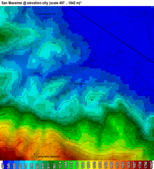
Below is the Elevation map of San Massimo, which displays elevation range with different colors. Scale of the first map is from 497 to 1842 m (1631 to 6043 ft) with average elevation of 799.4 meters (=2623 ft) [note 1]
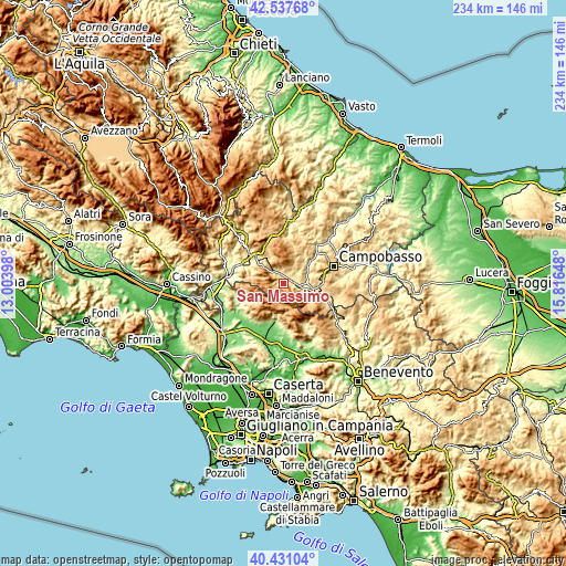
These maps also provides idea of topography and contour of this city, they are displayed at different zoom levels. More info about maps, scale and edge coordinates you can find below images.
| \ | Map #1 | Topo.Map |
| Scale [m] | 497..1842 m | × |
| Scale [ft] | 1631..6043 ft | × |
| Average | 799.4 m = 2623 ft | × |
| Width | 7.32 km = 4.5 mi | 234.2 km = 145.5 mi |
| Height | 7.32 km = 4.5 mi | 234.2 km = 145.5 mi |
| ↑Max Latitude | 41.525828° | 42.53768° |
| Latitude at center | 41.49292° | 41.49292° |
| ↓Min Latitude | 41.459995° | 40.43104° |
| ← Min Longitude | 14.366285° | 13.00398° |
| Longitude center | 14.41023° | 14.41023° |
| →Max Longitude | 14.454175° | 15.81648° |
Nearby cities:
Cities around San Massimo sort by population:
• Bojano elevation 485 m
5.1 km,  99°
99°
• Roccamandolfi 793 m
4.8 km,  273°
273°
• Campochiaro 669 m
9.6 km,  121°
121°
• Colle d'Anchise 648 m
9.2 km,  78°
78°
• Macchiagodena 821 m
7.3 km,  0°
0°
• Spinete 618 m
8.6 km,  48°
48°
• Santa Maria del Molise 641 m
7.5 km,  331°
331°
• Sant'Elena Sannita 769 m
10.4 km,  28°
28°
• Cantalupo nel Sannio 586 m
3.5 km,  335°
335°
• San Polomatese 734 m
7.9 km, 118°
• Castelpizzuto 872 m
10.3 km,  287°
287°
• Castelpetroso 842 m
9.2 km,  324°
324°
Multilingual:
 En español:
San Massimo elevación 615 m.
 En France:
San Massimo élévation 615 m.
 Auf Deutsch:
San Massimo höhe über dem Meeresspiegel ist 615 m.

Sources and notes:
- [note 1] Map square and city borders are not equal. Map elevation data is calculated only from area inside that square.
- [src 1] Elevation data from geonames database provided with same terms of usage.
- [src 2] The elevation map of San Massimo is generated using elevation data from NASA's 3 arcsec (90m) resolution SRTM data.
- [src 3] Base (background) map © OpenStreetMap contributors tiles are generated by Geofabrik and OpenTopoMap.
Copyright & License:
This San Massimo Elevation Map is licensed under CC BY-SA. You may reuse any part from this page, if you give a proper credit by linking to this URL:
 More info on terms of use page.