Buia elevation
Buia (Friuli Venezia Giulia, Provincia di Udine), Italy elevation is 193 meters and Buia elevation in feet is 633 ft above sea level [src 1]. Buia is a seat of a third-order administrative division (feature code) with elevation that is 129 meters (423 ft) smaller than average city elevation in Italy.
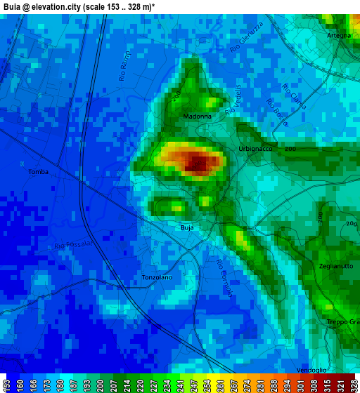
Below is the Elevation map of Buia, which displays elevation range with different colors. Scale of the first map is from 153 to 328 m (502 to 1076 ft) with average elevation of 181 meters (=594 ft) [note 1]
These maps also provides idea of topography and contour of this city, they are displayed at different zoom levels. More info about maps, scale and edge coordinates you can find below images.
| \ | Map #1 | Map #2 | Topo.Map |
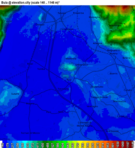
| Scale [m] | 153..328 m | 140..1146 m | × |
| Scale [ft] | 502..1076 ft | 459..3760 ft | × |
| Average | 181 m = 594 ft | 219.3 m = 719 ft | × |
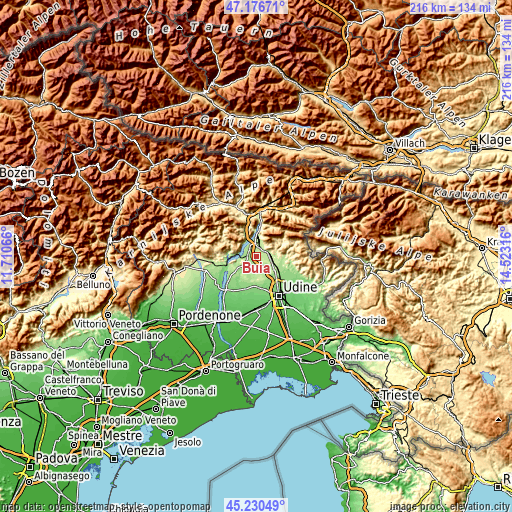
| Width | 6.76 km = 4.2 mi | 13.53 km = 8.4 mi | 216.4 km = 134.5 mi |
| Height | 6.76 km = 4.2 mi | 13.52 km = 8.4 mi | 216.4 km = 134.5 mi |
| ↑Max Latitude | 46.242621° | 46.273006° | 47.17671° |
| Latitude at center | 46.21222° | 46.21222° | 46.21222° |
| ↓Min Latitude | 46.181802° | 46.151367° | 45.23049° |
| ← Min Longitude | 13.072965° | 13.029019° | 11.71066° |
| Longitude center | 13.11691° | 13.11691° | 13.11691° |
| →Max Longitude | 13.160855° | 13.204801° | 14.52316° |
Nearby cities:
Cities around Buia sort by population:
• Gemona elevation 190 m
6.9 km,  3°
3°
• Majano 168 m
5.1 km,  237°
237°
• Cassacco 192 m
7.2 km,  126°
126°
• Artegna 200 m
4.1 km,  43°
43°
• Osoppo 184 m
5.4 km,  332°
332°
• Colloredo di Monte Albano 199 m
5.5 km,  162°
162°
• Magnano in Riviera 215 m
6.1 km,  77°
77°
• Treppo Grande 217 m
3.1 km,  115°
115°
• Colloredo di Monte Albano-Lauzzana 207 m
6 km,  175°
175°
• Montenars 399 m
5.9 km, 43°
• Isola 451 m
6.8 km, 44°
• Santo Stefano 214 m
0.8 km, 118°
Multilingual:
 En español:
Buia elevación 193 m.
 En France:
Buia élévation 193 m.


Sources and notes:
- [note 1] Map square and city borders are not equal. Map elevation data is calculated only from area inside that square.
- [src 1] Elevation data from geonames database provided with same terms of usage.
- [src 2] The elevation map of Buia is generated using elevation data from NASA's 3 arcsec (90m) resolution SRTM data.
- [src 3] Base (background) map © OpenStreetMap contributors tiles are generated by Geofabrik and OpenTopoMap.
Copyright & License:
This Buia Elevation Map is licensed under CC BY-SA. You may reuse any part from this page, if you give a proper credit by linking to this URL:
 More info on terms of use page.