Gemona elevation
Gemona (Friuli Venezia Giulia, Provincia di Udine), Italy elevation is 190 meters and Gemona elevation in feet is 623 ft above sea level [src 1]. Gemona is a seat of a third-order administrative division (feature code) with elevation that is 132 meters (433 ft) smaller than average city elevation in Italy.
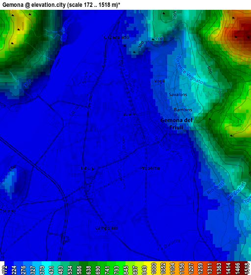
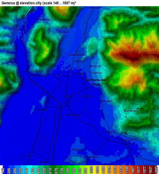
Below is the Elevation map of Gemona, which displays elevation range with different colors. Scale of the first map is from 172 to 1518 m (564 to 4980 ft) with average elevation of 310.8 meters (=1020 ft) [note 1]
These maps also provides idea of topography and contour of this city, they are displayed at different zoom levels. More info about maps, scale and edge coordinates you can find below images.
| \ | Map #1 | Map #2 | Topo.Map |
| Scale [m] | 172..1518 m | 140..1697 m | × |
| Scale [ft] | 564..4980 ft | 459..5568 ft | × |
| Average | 310.8 m = 1020 ft | 408 m = 1339 ft | × |
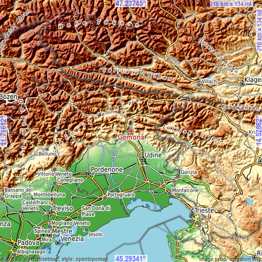
| Width | 6.75 km = 4.2 mi | 13.51 km = 8.4 mi | 216.2 km = 134.3 mi |
| Height | 6.75 km = 4.2 mi | 13.51 km = 8.4 mi | 216.1 km = 134.3 mi |
| ↑Max Latitude | 46.304417° | 46.334767° | 47.23745° |
| Latitude at center | 46.27405° | 46.27405° | 46.27405° |
| ↓Min Latitude | 46.243666° | 46.213265° | 45.29341° |
| ← Min Longitude | 13.078425° | 13.034479° | 11.71612° |
| Longitude center | 13.12237° | 13.12237° | 13.12237° |
| →Max Longitude | 13.166315° | 13.210261° | 14.52862° |
Nearby cities:
Cities around Gemona sort by population:
• Tarcento elevation 221 m
9.9 km,  133°
133°
• Buia 193 m
6.9 km,  183°
183°
• Artegna 200 m
4.6 km,  147°
147°
• Osoppo 184 m
3.6 km,  234°
234°
• Magnano in Riviera 215 m
7.9 km,  135°
135°
• Venzone 227 m
6.4 km,  11°
11°
• Treppo Grande 217 m
8.6 km,  163°
163°
• Bordano 221 m
4.8 km,  344°
344°
• Montenars 399 m
4.4 km, 125°
• Trasaghis 192 m
3.7 km,  283°
283°
• Isola 451 m
4.8 km,  115°
115°
• Santo Stefano 214 m
7.3 km, 177°
Multilingual:
 En español:
Gemona elevación 190 m.
 En France:
Gemona élévation 190 m.


Sources and notes:
- [note 1] Map square and city borders are not equal. Map elevation data is calculated only from area inside that square.
- [src 1] Elevation data from geonames database provided with same terms of usage.
- [src 2] The elevation map of Gemona is generated using elevation data from NASA's 3 arcsec (90m) resolution SRTM data.
- [src 3] Base (background) map © OpenStreetMap contributors tiles are generated by Geofabrik and OpenTopoMap.
Copyright & License:
This Gemona Elevation Map is licensed under CC BY-SA. You may reuse any part from this page, if you give a proper credit by linking to this URL:
 More info on terms of use page.