Calalzo di Cadore elevation
Calalzo di Cadore (Veneto, Provincia di Belluno), Italy elevation is 807 meters and Calalzo di Cadore elevation in feet is 2648 ft above sea level [src 1]. Calalzo di Cadore is a seat of a third-order administrative division (feature code) with elevation that is 485 meters (1591 ft) bigger than average city elevation in Italy.
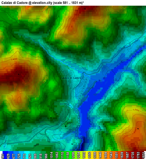
Below is the Elevation map of Calalzo di Cadore, which displays elevation range with different colors. Scale of the first map is from 581 to 1831 m (1906 to 6007 ft) with average elevation of 1056.4 meters (=3466 ft) [note 1]
These maps also provides idea of topography and contour of this city, they are displayed at different zoom levels. More info about maps, scale and edge coordinates you can find below images.
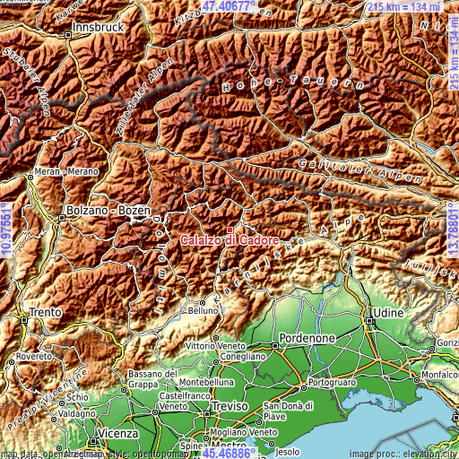
| \ | Map #1 | Topo.Map |
| Scale [m] | 581..1831 m | × |
| Scale [ft] | 1906..6007 ft | × |
| Average | 1056.4 m = 3466 ft | × |
| Width | 6.73 km = 4.2 mi | 215.5 km = 133.9 mi |
| Height | 6.73 km = 4.2 mi | 215.5 km = 133.9 mi |
| ↑Max Latitude | 46.476701° | 47.40677° |
| Latitude at center | 46.44643° | 46.44643° |
| ↓Min Latitude | 46.416142° | 45.46886° |
| ← Min Longitude | 12.337815° | 10.97551° |
| Longitude center | 12.38176° | 12.38176° |
| →Max Longitude | 12.425705° | 13.78801° |
Nearby cities:
Cities around Calalzo di Cadore sort by population:
• Auronzo elevation 887 m
13 km,  14°
14°
• Pieve di Cadore 843 m
2.8 km,  209°
209°
• Domegge di Cadore 768 m
2.3 km,  59°
59°
• San Vito 1022 m
13.6 km,  277°
277°
• Lozzo di Cadore 785 m
6.6 km,  47°
47°
• Valle di Cadore 845 m
4.8 km,  229°
229°
• Vodo 886 m
10.9 km,  253°
253°
• Borca 923 m
12.3 km,  263°
263°
• Lorenzago di Cadore 890 m
7 km, 58°
• Vigo di Cadore 939 m
9 km, 49°
• Cibiana 1026 m
9.7 km, 228°
• Perarolo di Cadore 528 m
6.2 km,  198°
198°
Multilingual:
 En español:
Calalzo di Cadore elevación 807 m.
 En France:
Calalzo di Cadore élévation 807 m.
 Auf Deutsch:
Calalzo di Cadore höhe über dem Meeresspiegel ist 807 m.

Sources and notes:
- [note 1] Map square and city borders are not equal. Map elevation data is calculated only from area inside that square.
- [src 1] Elevation data from geonames database provided with same terms of usage.
- [src 2] The elevation map of Calalzo di Cadore is generated using elevation data from NASA's 3 arcsec (90m) resolution SRTM data.
- [src 3] Base (background) map © OpenStreetMap contributors tiles are generated by Geofabrik and OpenTopoMap.
Copyright & License:
This Calalzo di Cadore Elevation Map is licensed under CC BY-SA. You may reuse any part from this page, if you give a proper credit by linking to this URL:
 More info on terms of use page.