Camerota elevation
Camerota (Campania, Provincia di Salerno), Italy elevation is 284 meters and Camerota elevation in feet is 932 ft above sea level [src 1]. Camerota is a seat of a third-order administrative division (feature code) with elevation that is 38 meters (125 ft) smaller than average city elevation in Italy.
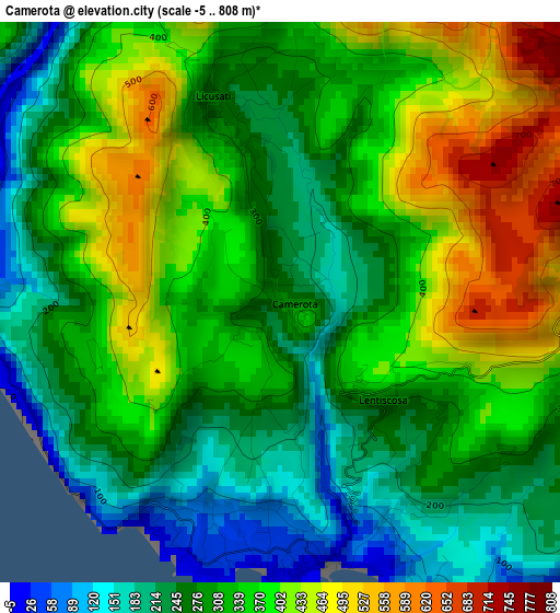
Below is the Elevation map of Camerota, which displays elevation range with different colors. Scale of the first map is from -5 to 808 m (-16 to 2651 ft) with average elevation of 326.5 meters (=1071 ft) [note 1]
These maps also provides idea of topography and contour of this city, they are displayed at different zoom levels. More info about maps, scale and edge coordinates you can find below images.
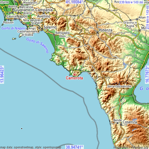
| \ | Map #1 | Topo.Map |
| Scale [m] | -5..808 m | × |
| Scale [ft] | -16..2651 ft | × |
| Average | 326.5 m = 1071 ft | × |
| Width | 7.48 km = 4.6 mi | 239.4 km = 148.8 mi |
| Height | 7.48 km = 4.6 mi | 239.4 km = 148.8 mi |
| ↑Max Latitude | 40.06626° | 41.10084° |
| Latitude at center | 40.03262° | 40.03262° |
| ↓Min Latitude | 39.998964° | 38.94741° |
| ← Min Longitude | 15.326535° | 13.96423° |
| Longitude center | 15.37048° | 15.37048° |
| →Max Longitude | 15.414425° | 16.77673° |
Nearby cities:
Cities around Camerota sort by population:
• Marina di Camerota elevation 42 m
3.2 km,  184°
184°
• San Giovanni A Piro 495 m
6.8 km,  71°
71°
• Policastro Bussentino 8 m
13.7 km, 69°
• Licusati 254 m
2.4 km,  347°
347°
• Torre Orsaia 287 m
14.1 km,  37°
37°
• Centola 289 m
6.5 km,  309°
309°
• Scario 197 m
9.4 km, 69°
• Celle di Bulgheria 228 m
7.5 km,  21°
21°
• Palinuro 59 m
7 km,  273°
273°
• Futani 445 m
13.8 km,  343°
343°
• Roccagloriosa 371 m
9.9 km,  34°
34°
• San Mauro la Bruca 426 m
12.1 km,  325°
325°
Multilingual:
 En español:
Camerota elevación 284 m.
 En France:
Camerota élévation 284 m.
 Auf Deutsch:
Camerota höhe über dem Meeresspiegel ist 284 m.

Sources and notes:
- [note 1] Map square and city borders are not equal. Map elevation data is calculated only from area inside that square.
- [src 1] Elevation data from geonames database provided with same terms of usage.
- [src 2] The elevation map of Camerota is generated using elevation data from NASA's 3 arcsec (90m) resolution SRTM data.
- [src 3] Base (background) map © OpenStreetMap contributors tiles are generated by Geofabrik and OpenTopoMap.
Copyright & License:
This Camerota Elevation Map is licensed under CC BY-SA. You may reuse any part from this page, if you give a proper credit by linking to this URL:
 More info on terms of use page.