Scario elevation
Scario (Campania, Provincia di Salerno), Italy elevation is 197 meters and Scario elevation in feet is 646 ft above sea level [src 1]. Scario is a populated place (feature code) with elevation that is 125 meters (410 ft) smaller than average city elevation in Italy.
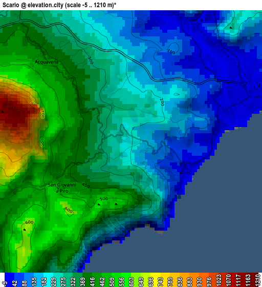
Below is the Elevation map of Scario, which displays elevation range with different colors. Scale of the first map is from -5 to 1210 m (-16 to 3970 ft) with average elevation of 307.4 meters (=1009 ft) [note 1]
These maps also provides idea of topography and contour of this city, they are displayed at different zoom levels. More info about maps, scale and edge coordinates you can find below images.
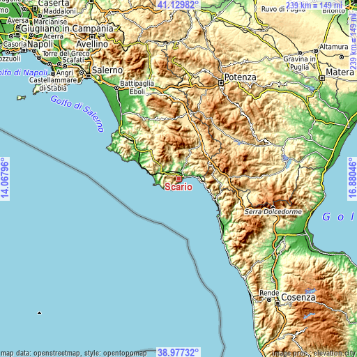
| \ | Map #1 | Topo.Map |
| Scale [m] | -5..1210 m | × |
| Scale [ft] | -16..3970 ft | × |
| Average | 307.4 m = 1009 ft | × |
| Width | 7.48 km = 4.6 mi | 239.3 km = 148.7 mi |
| Height | 7.48 km = 4.6 mi | 239.3 km = 148.7 mi |
| ↑Max Latitude | 40.095695° | 41.12982° |
| Latitude at center | 40.06207° | 40.06207° |
| ↓Min Latitude | 40.028428° | 38.97732° |
| ← Min Longitude | 15.430265° | 14.06796° |
| Longitude center | 15.47421° | 15.47421° |
| →Max Longitude | 15.518155° | 16.88046° |
Nearby cities:
Cities around Scario sort by population:
• San Giovanni A Piro elevation 495 m
2.7 km,  243°
243°
• Policastro Bussentino 8 m
4.3 km,  70°
70°
• Licusati 254 m
9.4 km,  264°
264°
• Torre Orsaia 287 m
7.9 km,  358°
358°
• Camerota 284 m
9.4 km,  249°
249°
• Celle di Bulgheria 228 m
7.1 km,  301°
301°
• Villammare 25 m
10.3 km,  80°
80°
• Vibonati 106 m
10.2 km, 66°
• Roccagloriosa 371 m
5.9 km,  326°
326°
• Santa Marina 405 m
7.5 km,  50°
50°
• Morigerati 290 m
11.1 km,  38°
38°
• Ispani 253 m
7.7 km, 68°
Multilingual:
 En español:
Scario elevación 197 m.
 En France:
Scario élévation 197 m.


Sources and notes:
- [note 1] Map square and city borders are not equal. Map elevation data is calculated only from area inside that square.
- [src 1] Elevation data from geonames database provided with same terms of usage.
- [src 2] The elevation map of Scario is generated using elevation data from NASA's 3 arcsec (90m) resolution SRTM data.
- [src 3] Base (background) map © OpenStreetMap contributors tiles are generated by Geofabrik and OpenTopoMap.
Copyright & License:
This Scario Elevation Map is licensed under CC BY-SA. You may reuse any part from this page, if you give a proper credit by linking to this URL:
 More info on terms of use page.