Casina elevation
Casina (Emilia-Romagna, Provincia di Reggio Emilia), Italy elevation is 570 meters and Casina elevation in feet is 1870 ft above sea level [src 1]. Casina is a seat of a third-order administrative division (feature code) with elevation that is 248 meters (814 ft) bigger than average city elevation in Italy.
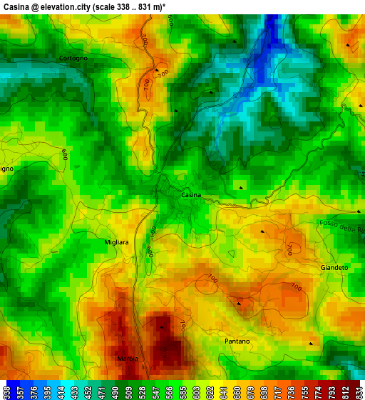
Below is the Elevation map of Casina, which displays elevation range with different colors. Scale of the first map is from 338 to 831 m (1109 to 2726 ft) with average elevation of 585.7 meters (=1922 ft) [note 1]
These maps also provides idea of topography and contour of this city, they are displayed at different zoom levels. More info about maps, scale and edge coordinates you can find below images.
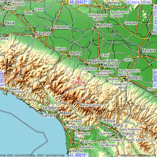
| \ | Map #1 | Topo.Map |
| Scale [m] | 338..831 m | × |
| Scale [ft] | 1109..2726 ft | × |
| Average | 585.7 m = 1922 ft | × |
| Width | 6.97 km = 4.3 mi | 223 km = 138.6 mi |
| Height | 6.97 km = 4.3 mi | 223 km = 138.6 mi |
| ↑Max Latitude | 44.54115° | 45.50403° |
| Latitude at center | 44.50982° | 44.50982° |
| ↓Min Latitude | 44.478473° | 43.49836° |
| ← Min Longitude | 10.455565° | 9.09326° |
| Longitude center | 10.49951° | 10.49951° |
| →Max Longitude | 10.543455° | 11.90576° |
Nearby cities:
Cities around Casina sort by population:
• Castelnovo ne'Monti elevation 711 m
11.2 km,  222°
222°
• San Polo d'Enza 175 m
14.2 km,  336°
336°
• Montecavolo 143 m
14.1 km,  14°
14°
• Quattro Castella 167 m
14.1 km,  351°
351°
• Vezzano sul Crostolo 188 m
10.9 km,  19°
19°
• Ciano d'Enza 202 m
12.2 km,  324°
324°
• Felina 670 m
6.9 km,  206°
206°
• Puianello 143 m
13.9 km, 21°
• Carpineti 546 m
6.2 km,  166°
166°
• Viano 218 m
10.6 km,  68°
68°
• Baiso 534 m
8.2 km,  100°
100°
• Vetto 442 m
13.1 km,  257°
257°
Multilingual:
 En español:
Casina elevación 570 m.
 En France:
Casina élévation 570 m.


Sources and notes:
- [note 1] Map square and city borders are not equal. Map elevation data is calculated only from area inside that square.
- [src 1] Elevation data from geonames database provided with same terms of usage.
- [src 2] The elevation map of Casina is generated using elevation data from NASA's 3 arcsec (90m) resolution SRTM data.
- [src 3] Base (background) map © OpenStreetMap contributors tiles are generated by Geofabrik and OpenTopoMap.
Copyright & License:
This Casina Elevation Map is licensed under CC BY-SA. You may reuse any part from this page, if you give a proper credit by linking to this URL:
 More info on terms of use page.