Cassinasco elevation
Cassinasco (Piedmont, Provincia di Asti), Italy elevation is 400 meters and Cassinasco elevation in feet is 1312 ft above sea level [src 1]. Cassinasco is a seat of a third-order administrative division (feature code) with elevation that is 78 meters (256 ft) bigger than average city elevation in Italy.
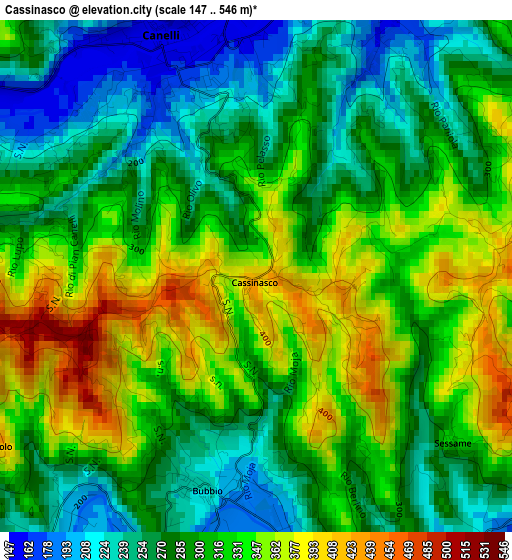
Below is the Elevation map of Cassinasco, which displays elevation range with different colors. Scale of the first map is from 147 to 546 m (482 to 1791 ft) with average elevation of 304.8 meters (=1000 ft) [note 1]
These maps also provides idea of topography and contour of this city, they are displayed at different zoom levels. More info about maps, scale and edge coordinates you can find below images.
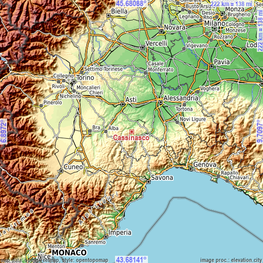
| \ | Map #1 | Topo.Map |
| Scale [m] | 147..546 m | × |
| Scale [ft] | 482..1791 ft | × |
| Average | 304.8 m = 1000 ft | × |
| Width | 6.95 km = 4.3 mi | 222.3 km = 138.1 mi |
| Height | 6.95 km = 4.3 mi | 222.3 km = 138.1 mi |
| ↑Max Latitude | 44.721003° | 45.68088° |
| Latitude at center | 44.68977° | 44.68977° |
| ↓Min Latitude | 44.65852° | 43.68141° |
| ← Min Longitude | 8.259505° | 6.8972° |
| Longitude center | 8.30345° | 8.30345° |
| →Max Longitude | 8.347395° | 9.7097° |
Nearby cities:
Cities around Cassinasco sort by population:
• Canelli elevation 152 m
3.6 km,  346°
346°
• Santo Stefano Belbo 174 m
6 km,  292°
292°
• Bistagno 178 m
6.3 km,  121°
121°
• Calamandrana 153 m
6 km,  26°
26°
• Monastero Bormida 195 m
4.9 km,  158°
158°
• Bubbio 231 m
3 km,  192°
192°
• Castel Boglione 267 m
7 km,  59°
59°
• Rocchetta Palafea 398 m
3.8 km, 59°
• Cessole 236 m
6.5 km,  225°
225°
• Montabone 449 m
7 km,  81°
81°
• Sessame 320 m
3.4 km,  128°
128°
• Loazzolo 427 m
4.2 km,  237°
237°
Multilingual:
 En español:
Cassinasco elevación 400 m.
 En France:
Cassinasco élévation 400 m.
 Auf Deutsch:
Cassinasco höhe über dem Meeresspiegel ist 400 m.

Sources and notes:
- [note 1] Map square and city borders are not equal. Map elevation data is calculated only from area inside that square.
- [src 1] Elevation data from geonames database provided with same terms of usage.
- [src 2] The elevation map of Cassinasco is generated using elevation data from NASA's 3 arcsec (90m) resolution SRTM data.
- [src 3] Base (background) map © OpenStreetMap contributors tiles are generated by Geofabrik and OpenTopoMap.
Copyright & License:
This Cassinasco Elevation Map is licensed under CC BY-SA. You may reuse any part from this page, if you give a proper credit by linking to this URL:
 More info on terms of use page.