Cassine elevation
Cassine (Piedmont, Provincia di Alessandria), Italy elevation is 135 meters and Cassine elevation in feet is 443 ft above sea level [src 1]. Cassine is a seat of a third-order administrative division (feature code) with elevation that is 187 meters (614 ft) smaller than average city elevation in Italy.
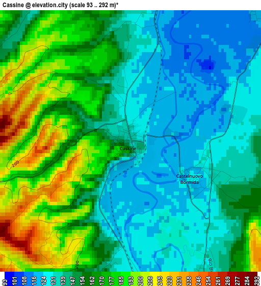
Below is the Elevation map of Cassine, which displays elevation range with different colors. Scale of the first map is from 93 to 292 m (305 to 958 ft) with average elevation of 155.8 meters (=511 ft) [note 1]
These maps also provides idea of topography and contour of this city, they are displayed at different zoom levels. More info about maps, scale and edge coordinates you can find below images.
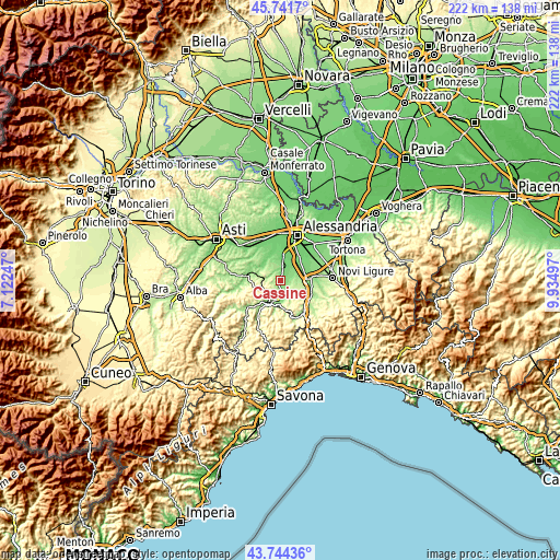
| \ | Map #1 | Topo.Map |
| Scale [m] | 93..292 m | × |
| Scale [ft] | 305..958 ft | × |
| Average | 155.8 m = 511 ft | × |
| Width | 6.94 km = 4.3 mi | 222.1 km = 138 mi |
| Height | 6.94 km = 4.3 mi | 222.1 km = 138 mi |
| ↑Max Latitude | 44.78286° | 45.7417° |
| Latitude at center | 44.75166° | 44.75166° |
| ↓Min Latitude | 44.720443° | 43.74436° |
| ← Min Longitude | 8.484775° | 7.12247° |
| Longitude center | 8.52872° | 8.52872° |
| →Max Longitude | 8.572665° | 9.93497° |
Nearby cities:
Cities around Cassine sort by population:
• Strevi elevation 135 m
5.8 km,  183°
183°
• Rivalta Bormida 147 m
5 km,  158°
158°
• Sezzadio 123 m
5.1 km,  43°
43°
• Castelnuovo Bormida 125 m
2 km,  120°
120°
• Mombaruzzo 286 m
6.7 km,  289°
289°
• Gamalero 144 m
6.4 km,  8°
8°
• Ricaldone 292 m
5.2 km,  245°
245°
• Castelspina 115 m
7.4 km, 35°
• Alice Bel Colle 403 m
6.8 km, 245°
• Maranzana 266 m
4.1 km,  283°
283°
• Orsara Bormida 225 m
7.3 km, 158°
• Quaranti 268 m
6.3 km,  269°
269°
Multilingual:
 En español:
Cassine elevación 135 m.
 En France:
Cassine élévation 135 m.


Sources and notes:
- [note 1] Map square and city borders are not equal. Map elevation data is calculated only from area inside that square.
- [src 1] Elevation data from geonames database provided with same terms of usage.
- [src 2] The elevation map of Cassine is generated using elevation data from NASA's 3 arcsec (90m) resolution SRTM data.
- [src 3] Base (background) map © OpenStreetMap contributors tiles are generated by Geofabrik and OpenTopoMap.
Copyright & License:
This Cassine Elevation Map is licensed under CC BY-SA. You may reuse any part from this page, if you give a proper credit by linking to this URL:
 More info on terms of use page.