Castelforte elevation
Castelforte (Latium, Provincia di Latina), Italy elevation is 52 meters and Castelforte elevation in feet is 171 ft above sea level [src 1]. Castelforte is a seat of a third-order administrative division (feature code) with elevation that is 270 meters (886 ft) smaller than average city elevation in Italy.
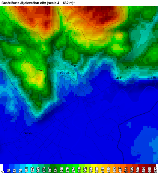
Below is the Elevation map of Castelforte, which displays elevation range with different colors. Scale of the first map is from 4 to 632 m (13 to 2073 ft) with average elevation of 148.4 meters (=487 ft) [note 1]
These maps also provides idea of topography and contour of this city, they are displayed at different zoom levels. More info about maps, scale and edge coordinates you can find below images.
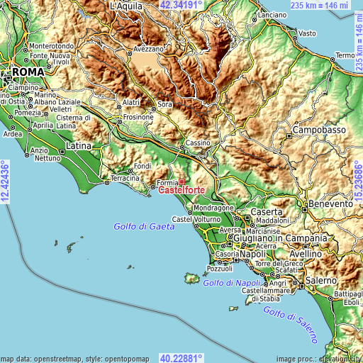
| \ | Map #1 | Topo.Map |
| Scale [m] | 4..632 m | × |
| Scale [ft] | 13..2073 ft | × |
| Average | 148.4 m = 487 ft | × |
| Width | 7.34 km = 4.6 mi | 235 km = 146 mi |
| Height | 7.34 km = 4.6 mi | 234.9 km = 146 mi |
| ↑Max Latitude | 41.326929° | 42.34191° |
| Latitude at center | 41.29392° | 41.29392° |
| ↓Min Latitude | 41.260894° | 40.22881° |
| ← Min Longitude | 13.786665° | 12.42436° |
| Longitude center | 13.83061° | 13.83061° |
| →Max Longitude | 13.874555° | 15.23686° |
Nearby cities:
Cities around Castelforte sort by population:
• Minturno elevation 128 m
7.9 km,  244°
244°
• Cellole 21 m
10.2 km,  169°
169°
• Sessa Aurunca 201 m
10.2 km,  125°
125°
• Grunuovo-Campomaggiore San Luca 15 m
3.1 km,  219°
219°
• Lauro 100 m
6 km,  123°
123°
• Coreno Ausonio 309 m
7.5 km,  322°
322°
• San Castrese 42 m
4.9 km,  143°
143°
• Spigno Saturnia Inferiore 53 m
8.1 km,  283°
283°
• Ausonia 165 m
9.8 km, 316°
• Santi Cosma e Damiano 167 m
1.5 km,  301°
301°
• Sant'Andrea del Garigliano 146 m
8.4 km,  6°
6°
• Vallemaio 293 m
8.3 km,  347°
347°
Multilingual:
 En español:
Castelforte elevación 52 m.
 En France:
Castelforte élévation 52 m.
 Auf Deutsch:
Castelforte höhe über dem Meeresspiegel ist 52 m.

Sources and notes:
- [note 1] Map square and city borders are not equal. Map elevation data is calculated only from area inside that square.
- [src 1] Elevation data from geonames database provided with same terms of usage.
- [src 2] The elevation map of Castelforte is generated using elevation data from NASA's 3 arcsec (90m) resolution SRTM data.
- [src 3] Base (background) map © OpenStreetMap contributors tiles are generated by Geofabrik and OpenTopoMap.
Copyright & License:
This Castelforte Elevation Map is licensed under CC BY-SA. You may reuse any part from this page, if you give a proper credit by linking to this URL:
 More info on terms of use page.