Castrocielo elevation
Castrocielo (Latium, Provincia di Frosinone), Italy elevation is 193 meters and Castrocielo elevation in feet is 633 ft above sea level [src 1]. Castrocielo is a seat of a third-order administrative division (feature code) with elevation that is 129 meters (423 ft) smaller than average city elevation in Italy.
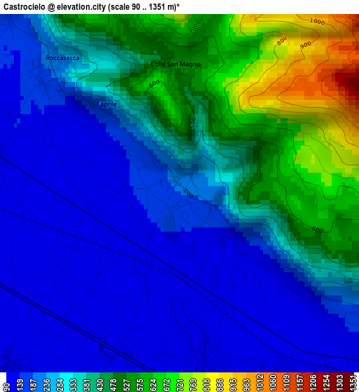
Below is the Elevation map of Castrocielo, which displays elevation range with different colors. Scale of the first map is from 90 to 1351 m (295 to 4432 ft) with average elevation of 329.5 meters (=1081 ft) [note 1]
These maps also provides idea of topography and contour of this city, they are displayed at different zoom levels. More info about maps, scale and edge coordinates you can find below images.
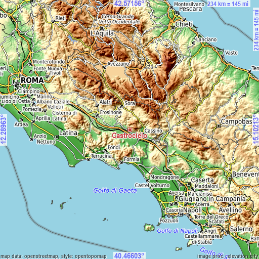
| \ | Map #1 | Topo.Map |
| Scale [m] | 90..1351 m | × |
| Scale [ft] | 295..4432 ft | × |
| Average | 329.5 m = 1081 ft | × |
| Width | 7.32 km = 4.5 mi | 234.1 km = 145.5 mi |
| Height | 7.32 km = 4.5 mi | 234.1 km = 145.5 mi |
| ↑Max Latitude | 41.560251° | 42.57156° |
| Latitude at center | 41.52736° | 41.52736° |
| ↓Min Latitude | 41.494452° | 40.46603° |
| ← Min Longitude | 13.651935° | 12.28963° |
| Longitude center | 13.69588° | 13.69588° |
| →Max Longitude | 13.739825° | 15.10213° |
Nearby cities:
Cities around Castrocielo sort by population:
• Pontecorvo elevation 96 m
8 km,  197°
197°
• Aquino 110 m
3.8 km,  168°
168°
• Roccasecca Stazione 134 m
3.9 km,  279°
279°
• Piedimonte San Germano 118 m
5.6 km,  125°
125°
• Piedimonte San Germano Alta 199 m
5.1 km,  119°
119°
• Caira 160 m
10.1 km,  86°
86°
• Roccasecca 240 m
3.6 km,  318°
318°
• Villa Santa Lucia 311 m
6.3 km,  105°
105°
• Coldragone 149 m
8.2 km,  291°
291°
• Colle San Magno 536 m
2.5 km,  358°
358°
• Santopadre 728 m
9.7 km,  328°
328°
• Terelle 957 m
7.4 km,  68°
68°
Multilingual:
 En español:
Castrocielo elevación 193 m.
 En France:
Castrocielo élévation 193 m.
 Auf Deutsch:
Castrocielo höhe über dem Meeresspiegel ist 193 m.

Sources and notes:
- [note 1] Map square and city borders are not equal. Map elevation data is calculated only from area inside that square.
- [src 1] Elevation data from geonames database provided with same terms of usage.
- [src 2] The elevation map of Castrocielo is generated using elevation data from NASA's 3 arcsec (90m) resolution SRTM data.
- [src 3] Base (background) map © OpenStreetMap contributors tiles are generated by Geofabrik and OpenTopoMap.
Copyright & License:
This Castrocielo Elevation Map is licensed under CC BY-SA. You may reuse any part from this page, if you give a proper credit by linking to this URL:
 More info on terms of use page.