Caira elevation
Caira (Latium, Provincia di Frosinone), Italy elevation is 160 meters and Caira elevation in feet is 525 ft above sea level [src 1]. Caira is a populated place (feature code) with elevation that is 162 meters (531 ft) smaller than average city elevation in Italy.
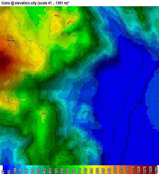
Below is the Elevation map of Caira, which displays elevation range with different colors. Scale of the first map is from 41 to 1381 m (135 to 4531 ft) with average elevation of 391.3 meters (=1284 ft) [note 1]
These maps also provides idea of topography and contour of this city, they are displayed at different zoom levels. More info about maps, scale and edge coordinates you can find below images.
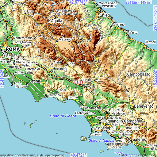
| \ | Map #1 | Topo.Map |
| Scale [m] | 41..1381 m | × |
| Scale [ft] | 135..4531 ft | × |
| Average | 391.3 m = 1284 ft | × |
| Width | 7.32 km = 4.5 mi | 234.1 km = 145.5 mi |
| Height | 7.32 km = 4.5 mi | 234.1 km = 145.5 mi |
| ↑Max Latitude | 41.566218° | 42.57743° |
| Latitude at center | 41.53333° | 41.53333° |
| ↓Min Latitude | 41.500425° | 40.4721° |
| ← Min Longitude | 13.772725° | 12.41042° |
| Longitude center | 13.81667° | 13.81667° |
| →Max Longitude | 13.860615° | 15.22292° |
Nearby cities:
Cities around Caira sort by population:
• Cassino elevation 40 m
5.4 km,  169°
169°
• Sant'Elia Fiumerapido 128 m
3.8 km,  90°
90°
• Cervaro 239 m
9.1 km,  128°
128°
• San Bartolomeo 55 m
6.6 km,  148°
148°
• Piedimonte San Germano 118 m
6.8 km,  234°
234°
• Piedimonte San Germano Alta 199 m
6.5 km,  240°
240°
• Villa Santa Lucia 311 m
4.6 km, 239°
• Villa Latina 423 m
9.2 km,  9°
9°
• Atina 473 m
9.8 km,  351°
351°
• Vallerotonda 588 m
8.3 km,  76°
76°
• Belmonte Castello 306 m
4.9 km,  359°
359°
• Terelle 957 m
3.8 km,  303°
303°
Multilingual:
 En español:
Caira elevación 160 m.
 En France:
Caira élévation 160 m.


Sources and notes:
- [note 1] Map square and city borders are not equal. Map elevation data is calculated only from area inside that square.
- [src 1] Elevation data from geonames database provided with same terms of usage.
- [src 2] The elevation map of Caira is generated using elevation data from NASA's 3 arcsec (90m) resolution SRTM data.
- [src 3] Base (background) map © OpenStreetMap contributors tiles are generated by Geofabrik and OpenTopoMap.
Copyright & License:
This Caira Elevation Map is licensed under CC BY-SA. You may reuse any part from this page, if you give a proper credit by linking to this URL:
 More info on terms of use page.