Cavargna elevation
Cavargna (Lombardy, Provincia di Como), Italy elevation is 1059 meters and Cavargna elevation in feet is 3474 ft above sea level [src 1]. Cavargna is a seat of a third-order administrative division (feature code) with elevation that is 737 meters (2418 ft) bigger than average city elevation in Italy.
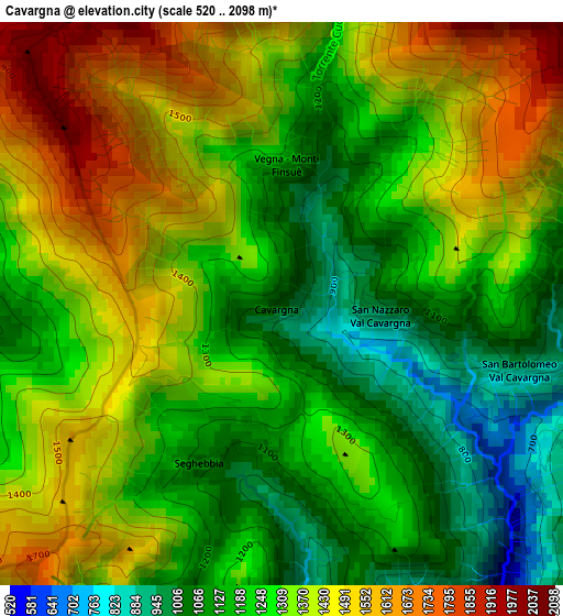
Below is the Elevation map of Cavargna, which displays elevation range with different colors. Scale of the first map is from 520 to 2098 m (1706 to 6883 ft) with average elevation of 1304.1 meters (=4279 ft) [note 1]
These maps also provides idea of topography and contour of this city, they are displayed at different zoom levels. More info about maps, scale and edge coordinates you can find below images.
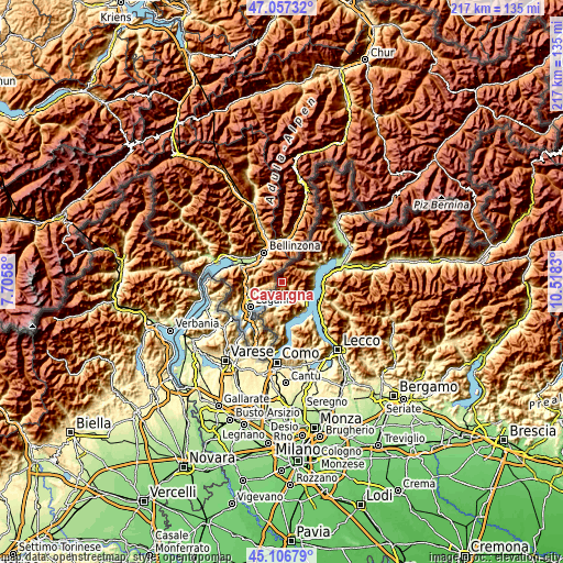
| \ | Map #1 | Topo.Map |
| Scale [m] | 520..2098 m | × |
| Scale [ft] | 1706..6883 ft | × |
| Average | 1304.1 m = 4279 ft | × |
| Width | 6.78 km = 4.2 mi | 216.9 km = 134.8 mi |
| Height | 6.78 km = 4.2 mi | 216.9 km = 134.8 mi |
| ↑Max Latitude | 46.121148° | 47.05732° |
| Latitude at center | 46.09068° | 46.09068° |
| ↓Min Latitude | 46.060195° | 45.10679° |
| ← Min Longitude | 9.068105° | 7.7058° |
| Longitude center | 9.11205° | 9.11205° |
| →Max Longitude | 9.155995° | 10.5183° |
Nearby cities:
Cities around Cavargna sort by population:
• Porlezza elevation 285 m
6.1 km,  167°
167°
• Carlazzo 304 m
6.8 km,  142°
142°
• San Bartolomeo Val Cavargna 895 m
3 km,  105°
105°
• Corrido 505 m
5.1 km,  159°
159°
• Osteno 287 m
9.6 km,  193°
193°
• Plesio 622 m
10.2 km,  118°
118°
• San Mamete 286 m
8.6 km,  211°
211°
• Osteno-Claino 383 m
9.9 km, 191°
• Bene Lario 381 m
8.8 km, 140°
• San Nazzaro Val Cavargna 943 m
1.2 km,  96°
96°
• Cusino 802 m
3.6 km, 119°
• Val Rezzo 1092 m
2 km,  180°
180°
Multilingual:
 En español:
Cavargna elevación 1059 m.
 En France:
Cavargna élévation 1059 m.
 Auf Deutsch:
Cavargna höhe über dem Meeresspiegel ist 1059 m.

Sources and notes:
- [note 1] Map square and city borders are not equal. Map elevation data is calculated only from area inside that square.
- [src 1] Elevation data from geonames database provided with same terms of usage.
- [src 2] The elevation map of Cavargna is generated using elevation data from NASA's 3 arcsec (90m) resolution SRTM data.
- [src 3] Base (background) map © OpenStreetMap contributors tiles are generated by Geofabrik and OpenTopoMap.
Copyright & License:
This Cavargna Elevation Map is licensed under CC BY-SA. You may reuse any part from this page, if you give a proper credit by linking to this URL:
 More info on terms of use page.