Porto Cesareo elevation
Porto Cesareo (Apulia, Provincia di Lecce), Italy elevation is 5 meters and Porto Cesareo elevation in feet is 16 ft above sea level [src 1]. Porto Cesareo is a seat of a third-order administrative division (feature code) with elevation that is 317 meters (1040 ft) smaller than average city elevation in Italy.
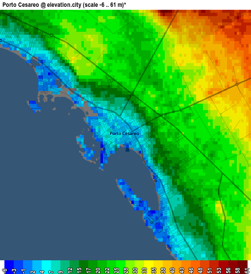
Below is the Elevation map of Porto Cesareo, which displays elevation range with different colors. Scale of the first map is from -6 to 61 m (-20 to 200 ft) with average elevation of 23.1 meters (=76 ft) [note 1]
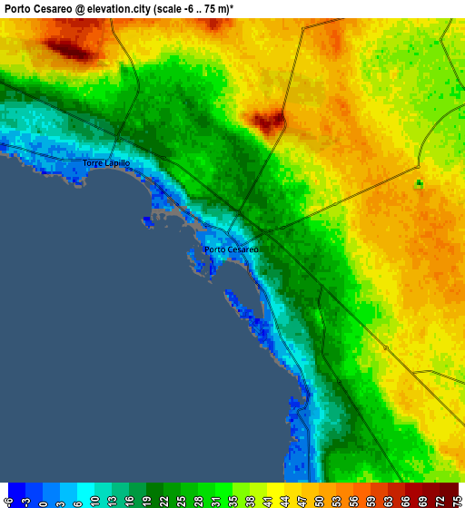
These maps also provides idea of topography and contour of this city, they are displayed at different zoom levels. More info about maps, scale and edge coordinates you can find below images.
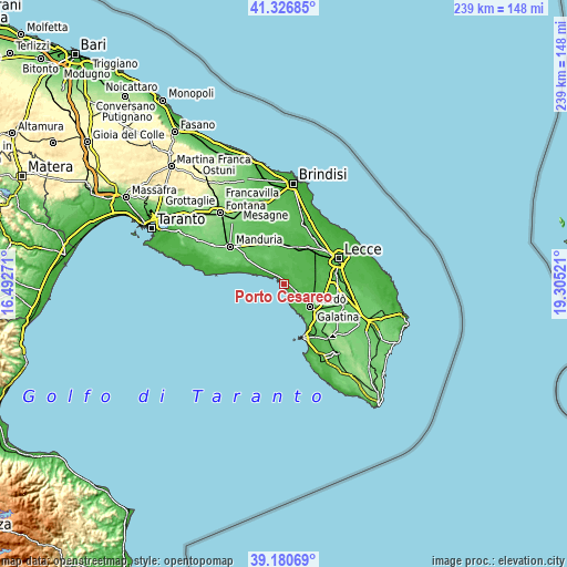
| \ | Map #1 | Map #2 | Topo.Map |
| Scale [m] | -6..61 m | -6..75 m | × |
| Scale [ft] | -20..200 ft | -20..246 ft | × |
| Average | 23.1 m = 76 ft | 34.2 m = 112 ft | × |
| Width | 7.46 km = 4.6 mi | 14.91 km = 9.3 mi | 238.6 km = 148.3 mi |
| Height | 7.46 km = 4.6 mi | 14.91 km = 9.3 mi | 238.6 km = 148.3 mi |
| ↑Max Latitude | 40.295806° | 40.329316° | 41.32685° |
| Latitude at center | 40.26228° | 40.26228° | 40.26228° |
| ↓Min Latitude | 40.228737° | 40.195178° | 39.18069° |
| ← Min Longitude | 17.855015° | 17.811069° | 16.49271° |
| Longitude center | 17.89896° | 17.89896° | 17.89896° |
| →Max Longitude | 17.942905° | 17.986851° | 19.30521° |
Nearby cities:
Cities around Porto Cesareo sort by population:
• Nardò elevation 47 m
14.6 km,  129°
129°
• Copertino 37 m
13.2 km,  87°
87°
• Veglie 50 m
9.7 km,  33°
33°
• Leverano 37 m
8.8 km,  70°
70°
• Monteroni di Lecce 38 m
17.5 km, 68°
• San Pancrazio Salentino 63 m
18.2 km,  342°
342°
• Carmiano 31 m
15.2 km,  53°
53°
• Salice Salentino 46 m
14.6 km,  21°
21°
• Novoli 38 m
17.9 km,  44°
44°
• Avetrana 58 m
17.2 km,  304°
304°
• Guagnano 46 m
16 km, 15°
• Magliano 38 m
16.2 km,  58°
58°
Multilingual:
 En español:
Porto Cesareo elevación 5 m.
 En France:
Porto Cesareo élévation 5 m.
 Auf Deutsch:
Porto Cesareo höhe über dem Meeresspiegel ist 5 m.

Sources and notes:
- [note 1] Map square and city borders are not equal. Map elevation data is calculated only from area inside that square.
- [src 1] Elevation data from geonames database provided with same terms of usage.
- [src 2] The elevation map of Porto Cesareo is generated using elevation data from NASA's 3 arcsec (90m) resolution SRTM data.
- [src 3] Base (background) map © OpenStreetMap contributors tiles are generated by Geofabrik and OpenTopoMap.
Copyright & License:
This Porto Cesareo Elevation Map is licensed under CC BY-SA. You may reuse any part from this page, if you give a proper credit by linking to this URL:
 More info on terms of use page.