Chiaromonte elevation
Chiaromonte (Basilicate, Provincia di Potenza), Italy elevation is 736 meters and Chiaromonte elevation in feet is 2415 ft above sea level [src 1]. Chiaromonte is a seat of a third-order administrative division (feature code) with elevation that is 414 meters (1358 ft) bigger than average city elevation in Italy.
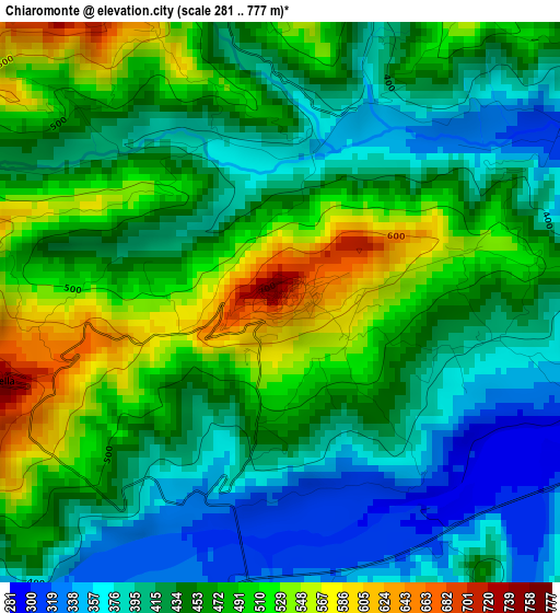
Below is the Elevation map of Chiaromonte, which displays elevation range with different colors. Scale of the first map is from 281 to 777 m (922 to 2549 ft) with average elevation of 450.1 meters (=1477 ft) [note 1]
These maps also provides idea of topography and contour of this city, they are displayed at different zoom levels. More info about maps, scale and edge coordinates you can find below images.
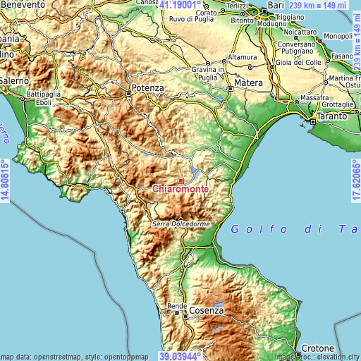
| \ | Map #1 | Topo.Map |
| Scale [m] | 281..777 m | × |
| Scale [ft] | 922..2549 ft | × |
| Average | 450.1 m = 1477 ft | × |
| Width | 7.47 km = 4.6 mi | 239.1 km = 148.6 mi |
| Height | 7.47 km = 4.6 mi | 239.1 km = 148.6 mi |
| ↑Max Latitude | 40.156825° | 41.19001° |
| Latitude at center | 40.12323° | 40.12323° |
| ↓Min Latitude | 40.089618° | 39.03944° |
| ← Min Longitude | 16.170455° | 14.80815° |
| Longitude center | 16.2144° | 16.2144° |
| →Max Longitude | 16.258345° | 17.62065° |
Nearby cities:
Cities around Chiaromonte sort by population:
• Senise elevation 350 m
6.8 km,  68°
68°
• Francavilla in Sinni 424 m
4.7 km,  190°
190°
• Roccanova 667 m
10 km,  355°
355°
• Episcopia 528 m
11.3 km,  241°
241°
• Noepoli 648 m
10.5 km,  112°
112°
• San Severino Lucano 897 m
13.1 km,  209°
209°
• Carbone 737 m
10.9 km,  281°
281°
• Castronuovo di Sant'Andrea 690 m
7.7 km,  341°
341°
• Teana 781 m
5.2 km,  273°
273°
• Fardella 750 m
3.9 km,  254°
254°
• San Costantino Albanese 648 m
12.3 km,  141°
141°
• Calvera 616 m
6.7 km,  295°
295°
Multilingual:
 En español:
Chiaromonte elevación 736 m.
 En France:
Chiaromonte élévation 736 m.
 Auf Deutsch:
Chiaromonte höhe über dem Meeresspiegel ist 736 m.

Sources and notes:
- [note 1] Map square and city borders are not equal. Map elevation data is calculated only from area inside that square.
- [src 1] Elevation data from geonames database provided with same terms of usage.
- [src 2] The elevation map of Chiaromonte is generated using elevation data from NASA's 3 arcsec (90m) resolution SRTM data.
- [src 3] Base (background) map © OpenStreetMap contributors tiles are generated by Geofabrik and OpenTopoMap.
Copyright & License:
This Chiaromonte Elevation Map is licensed under CC BY-SA. You may reuse any part from this page, if you give a proper credit by linking to this URL:
 More info on terms of use page.