Cicerale elevation
Cicerale (Campania, Provincia di Salerno), Italy elevation is 492 meters and Cicerale elevation in feet is 1614 ft above sea level [src 1]. Cicerale is a seat of a third-order administrative division (feature code) with elevation that is 170 meters (558 ft) bigger than average city elevation in Italy.
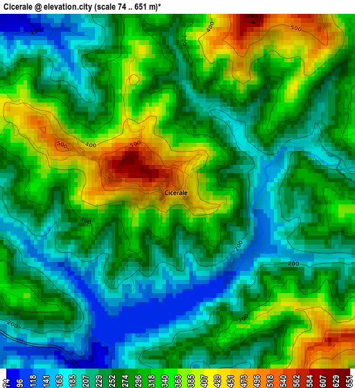
Below is the Elevation map of Cicerale, which displays elevation range with different colors. Scale of the first map is from 74 to 651 m (243 to 2136 ft) with average elevation of 285 meters (=935 ft) [note 1]
These maps also provides idea of topography and contour of this city, they are displayed at different zoom levels. More info about maps, scale and edge coordinates you can find below images.
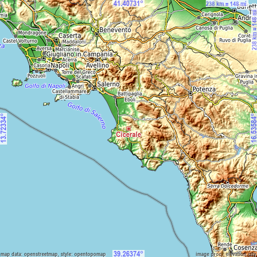
| \ | Map #1 | Topo.Map |
| Scale [m] | 74..651 m | × |
| Scale [ft] | 243..2136 ft | × |
| Average | 285 m = 935 ft | × |
| Width | 7.45 km = 4.6 mi | 238.3 km = 148.1 mi |
| Height | 7.45 km = 4.6 mi | 238.3 km = 148.1 mi |
| ↑Max Latitude | 40.377526° | 41.40731° |
| Latitude at center | 40.34404° | 40.34404° |
| ↓Min Latitude | 40.310538° | 39.26374° |
| ← Min Longitude | 15.085645° | 13.72334° |
| Longitude center | 15.12959° | 15.12959° |
| →Max Longitude | 15.173535° | 16.53584° |
Nearby cities:
Cities around Cicerale sort by population:
• Ogliastro Cilento elevation 324 m
7.1 km,  276°
276°
• Trentinara 567 m
6.3 km,  349°
349°
• Prignano Cilento 420 m
5.4 km,  257°
257°
• Rutino 334 m
6.8 km,  224°
224°
• Orria 536 m
6.1 km,  144°
144°
• Torchiara 345 m
6.9 km,  248°
248°
• Monteforte Cilento 584 m
6 km,  67°
67°
• Perito 460 m
5.3 km,  163°
163°
• Giungano 232 m
5.9 km,  341°
341°
• Lustra 469 m
8.1 km, 219°
• Magliano Vetere 654 m
9.1 km,  87°
87°
• Laureana Cilento 405 m
9.1 km,  238°
238°
Multilingual:
 En español:
Cicerale elevación 492 m.
 En France:
Cicerale élévation 492 m.
 Auf Deutsch:
Cicerale höhe über dem Meeresspiegel ist 492 m.

Sources and notes:
- [note 1] Map square and city borders are not equal. Map elevation data is calculated only from area inside that square.
- [src 1] Elevation data from geonames database provided with same terms of usage.
- [src 2] The elevation map of Cicerale is generated using elevation data from NASA's 3 arcsec (90m) resolution SRTM data.
- [src 3] Base (background) map © OpenStreetMap contributors tiles are generated by Geofabrik and OpenTopoMap.
Copyright & License:
This Cicerale Elevation Map is licensed under CC BY-SA. You may reuse any part from this page, if you give a proper credit by linking to this URL:
 More info on terms of use page.