Colere elevation
Colere (Lombardy, Provincia di Bergamo), Italy elevation is 1014 meters and Colere elevation in feet is 3327 ft above sea level [src 1]. Colere is a seat of a third-order administrative division (feature code) with elevation that is 692 meters (2270 ft) bigger than average city elevation in Italy.
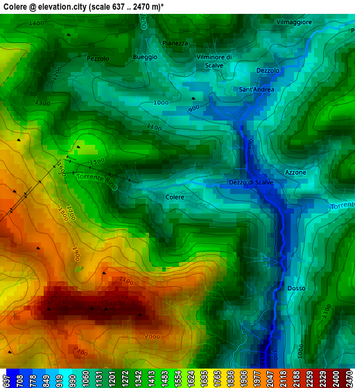
Below is the Elevation map of Colere, which displays elevation range with different colors. Scale of the first map is from 637 to 2470 m (2090 to 8104 ft) with average elevation of 1345.9 meters (=4416 ft) [note 1]
These maps also provides idea of topography and contour of this city, they are displayed at different zoom levels. More info about maps, scale and edge coordinates you can find below images.
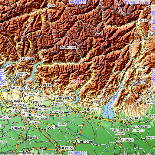
| \ | Map #1 | Topo.Map |
| Scale [m] | 637..2470 m | × |
| Scale [ft] | 2090..8104 ft | × |
| Average | 1345.9 m = 4416 ft | × |
| Width | 6.79 km = 4.2 mi | 217.3 km = 135 mi |
| Height | 6.79 km = 4.2 mi | 217.3 km = 135 mi |
| ↑Max Latitude | 46.005752° | 46.9439° |
| Latitude at center | 45.97522° | 45.97522° |
| ↓Min Latitude | 45.944671° | 44.98929° |
| ← Min Longitude | 10.039615° | 8.67731° |
| Longitude center | 10.08356° | 10.08356° |
| →Max Longitude | 10.127505° | 11.48981° |
Nearby cities:
Cities around Colere sort by population:
• Castione della Presolana elevation 960 m
7.1 km,  197°
197°
• Borno 911 m
9.7 km,  108°
108°
• Angolo Terme 374 m
10.6 km,  151°
151°
• Vilminore di Scalve 1035 m
2.7 km,  17°
17°
• Fino del Monte 695 m
11.5 km,  217°
217°
• Schilpario 1108 m
6.7 km,  56°
56°
• Onore 700 m
10.9 km,  211°
211°
• Bondione 913 m
8.9 km,  319°
319°
• Vilminore 1032 m
2.7 km, 19°
• Ossimo Superiore 874 m
11.8 km, 105°
• Gandellino 677 m
10.8 km,  279°
279°
• Azzone 986 m
2.3 km,  79°
79°
Multilingual:
 En español:
Colere elevación 1014 m.
 En France:
Colere élévation 1014 m.


Sources and notes:
- [note 1] Map square and city borders are not equal. Map elevation data is calculated only from area inside that square.
- [src 1] Elevation data from geonames database provided with same terms of usage.
- [src 2] The elevation map of Colere is generated using elevation data from NASA's 3 arcsec (90m) resolution SRTM data.
- [src 3] Base (background) map © OpenStreetMap contributors tiles are generated by Geofabrik and OpenTopoMap.
Copyright & License:
This Colere Elevation Map is licensed under CC BY-SA. You may reuse any part from this page, if you give a proper credit by linking to this URL:
 More info on terms of use page.