Collelongo elevation
Collelongo (Abruzzo, Provincia dell' Aquila), Italy elevation is 895 meters and Collelongo elevation in feet is 2936 ft above sea level [src 1]. Collelongo is a seat of a third-order administrative division (feature code) with elevation that is 573 meters (1880 ft) bigger than average city elevation in Italy.
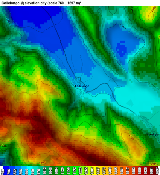
Below is the Elevation map of Collelongo, which displays elevation range with different colors. Scale of the first map is from 760 to 1697 m (2493 to 5568 ft) with average elevation of 1119.2 meters (=3672 ft) [note 1]
These maps also provides idea of topography and contour of this city, they are displayed at different zoom levels. More info about maps, scale and edge coordinates you can find below images.
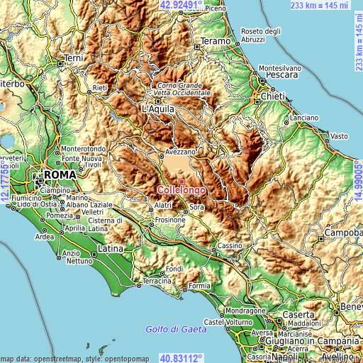
| \ | Map #1 | Topo.Map |
| Scale [m] | 760..1697 m | × |
| Scale [ft] | 2493..5568 ft | × |
| Average | 1119.2 m = 3672 ft | × |
| Width | 7.28 km = 4.5 mi | 232.8 km = 144.7 mi |
| Height | 7.28 km = 4.5 mi | 232.8 km = 144.7 mi |
| ↑Max Latitude | 41.919297° | 42.92491° |
| Latitude at center | 41.88659° | 41.88659° |
| ↓Min Latitude | 41.853866° | 40.83112° |
| ← Min Longitude | 13.539855° | 12.17755° |
| Longitude center | 13.5838° | 13.5838° |
| →Max Longitude | 13.627745° | 14.99005° |
Nearby cities:
Cities around Collelongo sort by population:
• Trasacco elevation 688 m
8.9 km,  331°
331°
• Luco dei Marsi 662 m
12.2 km,  311°
311°
• Balsorano 356 m
8.8 km,  193°
193°
• Gioia dei Marsi 697 m
11.8 km,  48°
48°
• Balsorano Nuovo 355 m
8.9 km, 192°
• Ortucchio 671 m
9.2 km,  34°
34°
• Lecce Nei Marsi 738 m
9.9 km,  57°
57°
• Roccavivi 474 m
9.2 km,  205°
205°
• Villavallelonga 956 m
3.5 km,  119°
119°
• Morino 441 m
10.8 km,  256°
256°
• Civita d'Antino 895 m
9.2 km,  269°
269°
• San Vincenzo Valle Roveto 568 m
6.1 km,  220°
220°
Multilingual:
 En español:
Collelongo elevación 895 m.
 En France:
Collelongo élévation 895 m.
 Auf Deutsch:
Collelongo höhe über dem Meeresspiegel ist 895 m.

Sources and notes:
- [note 1] Map square and city borders are not equal. Map elevation data is calculated only from area inside that square.
- [src 1] Elevation data from geonames database provided with same terms of usage.
- [src 2] The elevation map of Collelongo is generated using elevation data from NASA's 3 arcsec (90m) resolution SRTM data.
- [src 3] Base (background) map © OpenStreetMap contributors tiles are generated by Geofabrik and OpenTopoMap.
Copyright & License:
This Collelongo Elevation Map is licensed under CC BY-SA. You may reuse any part from this page, if you give a proper credit by linking to this URL:
 More info on terms of use page.