Contursi Terme elevation
Contursi Terme (Campania, Provincia di Salerno), Italy elevation is 279 meters and Contursi Terme elevation in feet is 915 ft above sea level [src 1]. Contursi Terme is a seat of a third-order administrative division (feature code) with elevation that is 43 meters (141 ft) smaller than average city elevation in Italy.
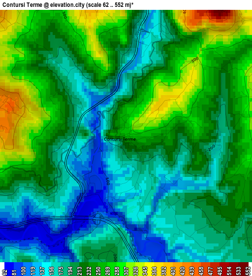
Below is the Elevation map of Contursi Terme, which displays elevation range with different colors. Scale of the first map is from 62 to 552 m (203 to 1811 ft) with average elevation of 217 meters (=712 ft) [note 1]
These maps also provides idea of topography and contour of this city, they are displayed at different zoom levels. More info about maps, scale and edge coordinates you can find below images.
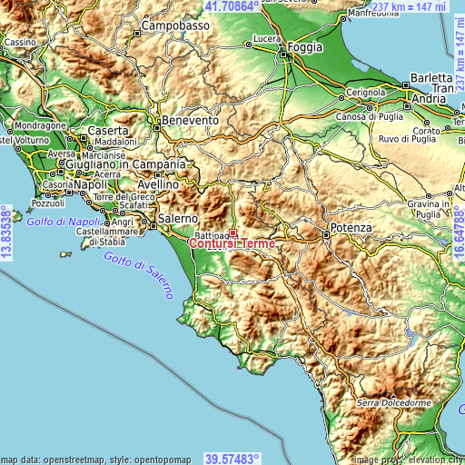
| \ | Map #1 | Topo.Map |
| Scale [m] | 62..552 m | × |
| Scale [ft] | 203..1811 ft | × |
| Average | 217 m = 712 ft | × |
| Width | 7.41 km = 4.6 mi | 237.3 km = 147.5 mi |
| Height | 7.41 km = 4.6 mi | 237.3 km = 147.5 mi |
| ↑Max Latitude | 40.683593° | 41.70864° |
| Latitude at center | 40.65026° | 40.65026° |
| ↓Min Latitude | 40.61691° | 39.57483° |
| ← Min Longitude | 15.197685° | 13.83538° |
| Longitude center | 15.24163° | 15.24163° |
| →Max Longitude | 15.285575° | 16.64788° |
Nearby cities:
Cities around Contursi Terme sort by population:
• Quadrivio elevation 138 m
12 km,  256°
256°
• San Gregorio Magno 512 m
13.3 km,  85°
85°
• Campagna 287 m
11.6 km,  279°
279°
• Buccino 578 m
11.9 km,  97°
97°
• Serre 223 m
8.9 km,  212°
212°
• Oliveto Citra 324 m
4.5 km,  351°
351°
• Colliano 519 m
9 km,  26°
26°
• Sicignano degli Alburni 606 m
11.5 km,  152°
152°
• Postiglione 637 m
10.2 km,  184°
184°
• Valva 474 m
10.1 km,  12°
12°
• Senerchia 598 m
10.6 km,  343°
343°
• Palomonte 538 m
4.5 km,  72°
72°
Multilingual:
 En español:
Contursi Terme elevación 279 m.
 En France:
Contursi Terme élévation 279 m.
 Auf Deutsch:
Contursi Terme höhe über dem Meeresspiegel ist 279 m.

Sources and notes:
- [note 1] Map square and city borders are not equal. Map elevation data is calculated only from area inside that square.
- [src 1] Elevation data from geonames database provided with same terms of usage.
- [src 2] The elevation map of Contursi Terme is generated using elevation data from NASA's 3 arcsec (90m) resolution SRTM data.
- [src 3] Base (background) map © OpenStreetMap contributors tiles are generated by Geofabrik and OpenTopoMap.
Copyright & License:
This Contursi Terme Elevation Map is licensed under CC BY-SA. You may reuse any part from this page, if you give a proper credit by linking to this URL:
 More info on terms of use page.