Diano Castello elevation
Diano Castello (Liguria, Provincia di Imperia), Italy elevation is 125 meters and Diano Castello elevation in feet is 410 ft above sea level [src 1]. Diano Castello is a seat of a third-order administrative division (feature code) with elevation that is 197 meters (646 ft) smaller than average city elevation in Italy.
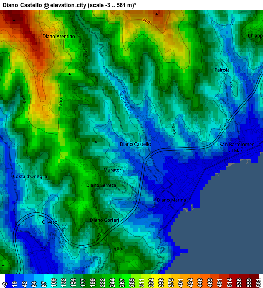
Below is the Elevation map of Diano Castello, which displays elevation range with different colors. Scale of the first map is from -3 to 581 m (-10 to 1906 ft) with average elevation of 161.8 meters (=531 ft) [note 1]
These maps also provides idea of topography and contour of this city, they are displayed at different zoom levels. More info about maps, scale and edge coordinates you can find below images.
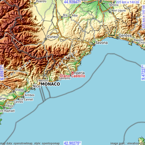
| \ | Map #1 | Topo.Map |
| Scale [m] | -3..581 m | × |
| Scale [ft] | -10..1906 ft | × |
| Average | 161.8 m = 531 ft | × |
| Width | 7.04 km = 4.4 mi | 225.2 km = 139.9 mi |
| Height | 7.04 km = 4.4 mi | 225.2 km = 139.9 mi |
| ↑Max Latitude | 43.955874° | 44.92847° |
| Latitude at center | 43.92423° | 43.92423° |
| ↓Min Latitude | 43.89257° | 42.90275° |
| ← Min Longitude | 8.022075° | 6.65977° |
| Longitude center | 8.06602° | 8.06602° |
| →Max Longitude | 8.109965° | 9.47227° |
Nearby cities:
Cities around Diano Castello sort by population:
• Imperia elevation 9 m
4.4 km,  208°
208°
• Andora 7 m
6.9 km,  60°
60°
• Diano Marina 6 m
1.9 km,  142°
142°
• Marina di Andora 45 m
7.8 km,  65°
65°
• San Bartolomeo al Mare 4 m
3.1 km,  92°
92°
• Pontedassio 61 m
4.4 km,  290°
290°
• Cervo 61 m
3.9 km, 87°
• Diano San Pietro 65 m
0.8 km,  41°
41°
• Chiusavecchia 145 m
8.1 km,  306°
306°
• Diano Arentino 311 m
3.4 km,  325°
325°
• Chiusanico 375 m
8 km, 312°
• Villa Faraldi 332 m
5.3 km,  21°
21°
Multilingual:
 En español:
Diano Castello elevación 125 m.
 En France:
Diano Castello élévation 125 m.
 Auf Deutsch:
Diano Castello höhe über dem Meeresspiegel ist 125 m.

Sources and notes:
- [note 1] Map square and city borders are not equal. Map elevation data is calculated only from area inside that square.
- [src 1] Elevation data from geonames database provided with same terms of usage.
- [src 2] The elevation map of Diano Castello is generated using elevation data from NASA's 3 arcsec (90m) resolution SRTM data.
- [src 3] Base (background) map © OpenStreetMap contributors tiles are generated by Geofabrik and OpenTopoMap.
Copyright & License:
This Diano Castello Elevation Map is licensed under CC BY-SA. You may reuse any part from this page, if you give a proper credit by linking to this URL:
 More info on terms of use page.