Erto elevation
Erto (Friuli Venezia Giulia, Provincia di Pordenone), Italy elevation is 823 meters and Erto elevation in feet is 2700 ft above sea level [src 1]. Erto is a seat of a third-order administrative division (feature code) with elevation that is 501 meters (1644 ft) bigger than average city elevation in Italy.
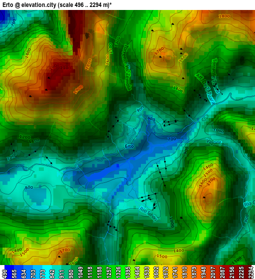
Below is the Elevation map of Erto, which displays elevation range with different colors. Scale of the first map is from 496 to 2294 m (1627 to 7526 ft) with average elevation of 1225.5 meters (=4021 ft) [note 1]
These maps also provides idea of topography and contour of this city, they are displayed at different zoom levels. More info about maps, scale and edge coordinates you can find below images.
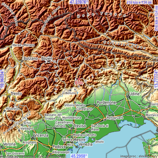
| \ | Map #1 | Topo.Map |
| Scale [m] | 496..2294 m | × |
| Scale [ft] | 1627..7526 ft | × |
| Average | 1225.5 m = 4021 ft | × |
| Width | 6.75 km = 4.2 mi | 216.1 km = 134.3 mi |
| Height | 6.75 km = 4.2 mi | 216.1 km = 134.3 mi |
| ↑Max Latitude | 46.306766° | 47.23976° |
| Latitude at center | 46.2764° | 46.2764° |
| ↓Min Latitude | 46.246017° | 45.2958° |
| ← Min Longitude | 12.327545° | 10.96524° |
| Longitude center | 12.37149° | 12.37149° |
| →Max Longitude | 12.415435° | 13.77774° |
Nearby cities:
Cities around Erto sort by population:
• Ponte nelle Alpi elevation 402 m
12.6 km,  212°
212°
• Ponte nelle Alpi-Polpet 402 m
12.1 km,  216°
216°
• Longarone 484 m
5.6 km,  257°
257°
• Soccher-Paiane-Casan-Arsie 402 m
11.6 km,  204°
204°
• Claut 614 m
11 km,  94°
94°
• Cimolais 657 m
5.3 km,  74°
74°
• Pieve d'Alpago 668 m
12.3 km,  186°
186°
• Soverzene 421 m
9.7 km, 212°
• Lamosano 642 m
11.6 km,  174°
174°
• Ospitale di Cadore 499 m
6.9 km,  326°
326°
• Cibiana 1026 m
14.1 km, 332°
• Perarolo di Cadore 528 m
13.1 km,  354°
354°
Multilingual:
 En español:
Erto elevación 823 m.
 En France:
Erto élévation 823 m.


Sources and notes:
- [note 1] Map square and city borders are not equal. Map elevation data is calculated only from area inside that square.
- [src 1] Elevation data from geonames database provided with same terms of usage.
- [src 2] The elevation map of Erto is generated using elevation data from NASA's 3 arcsec (90m) resolution SRTM data.
- [src 3] Base (background) map © OpenStreetMap contributors tiles are generated by Geofabrik and OpenTopoMap.
Copyright & License:
This Erto Elevation Map is licensed under CC BY-SA. You may reuse any part from this page, if you give a proper credit by linking to this URL:
 More info on terms of use page.