Soverzene elevation
Soverzene (Veneto, Provincia di Belluno), Italy elevation is 421 meters and Soverzene elevation in feet is 1381 ft above sea level [src 1]. Soverzene is a seat of a third-order administrative division (feature code) with elevation that is 99 meters (325 ft) bigger than average city elevation in Italy.
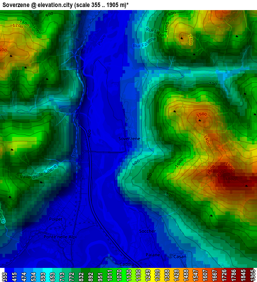
Below is the Elevation map of Soverzene, which displays elevation range with different colors. Scale of the first map is from 355 to 1905 m (1165 to 6250 ft) with average elevation of 773.2 meters (=2537 ft) [note 1]
These maps also provides idea of topography and contour of this city, they are displayed at different zoom levels. More info about maps, scale and edge coordinates you can find below images.
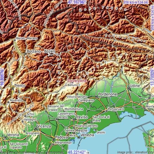
| \ | Map #1 | Topo.Map |
| Scale [m] | 355..1905 m | × |
| Scale [ft] | 1165..6250 ft | × |
| Average | 773.2 m = 2537 ft | × |
| Width | 6.76 km = 4.2 mi | 216.4 km = 134.5 mi |
| Height | 6.76 km = 4.2 mi | 216.4 km = 134.5 mi |
| ↑Max Latitude | 46.233716° | 47.16796° |
| Latitude at center | 46.20331° | 46.20331° |
| ↓Min Latitude | 46.172887° | 45.22142° |
| ← Min Longitude | 12.259065° | 10.89676° |
| Longitude center | 12.30301° | 12.30301° |
| →Max Longitude | 12.346955° | 13.70926° |
Nearby cities:
Cities around Soverzene sort by population:
• Belluno elevation 398 m
9.5 km,  224°
224°
• Ponte nelle Alpi 402 m
2.9 km,  211°
211°
• Ponte nelle Alpi-Polpet 402 m
2.5 km,  228°
228°
• Castion 421 m
10.5 km, 209°
• Longarone 484 m
7 km,  358°
358°
• Farra d'Alpago 398 m
10.1 km,  154°
154°
• Puos d'Alpago 416 m
8.2 km, 146°
• Soccher-Paiane-Casan-Arsie 402 m
2.5 km,  167°
167°
• Tambre 918 m
12.4 km,  133°
133°
• Pieve d'Alpago 668 m
5.6 km,  136°
136°
• Erto 823 m
9.7 km,  32°
32°
• Lamosano 642 m
7.3 km,  117°
117°
Multilingual:
 En español:
Soverzene elevación 421 m.
 En France:
Soverzene élévation 421 m.
 Auf Deutsch:
Soverzene höhe über dem Meeresspiegel ist 421 m.

Sources and notes:
- [note 1] Map square and city borders are not equal. Map elevation data is calculated only from area inside that square.
- [src 1] Elevation data from geonames database provided with same terms of usage.
- [src 2] The elevation map of Soverzene is generated using elevation data from NASA's 3 arcsec (90m) resolution SRTM data.
- [src 3] Base (background) map © OpenStreetMap contributors tiles are generated by Geofabrik and OpenTopoMap.
Copyright & License:
This Soverzene Elevation Map is licensed under CC BY-SA. You may reuse any part from this page, if you give a proper credit by linking to this URL:
 More info on terms of use page.