Faeto elevation
Faeto (Apulia, Provincia di Foggia), Italy elevation is 819 meters and Faeto elevation in feet is 2687 ft above sea level [src 1]. Faeto is a seat of a third-order administrative division (feature code) with elevation that is 497 meters (1631 ft) bigger than average city elevation in Italy.
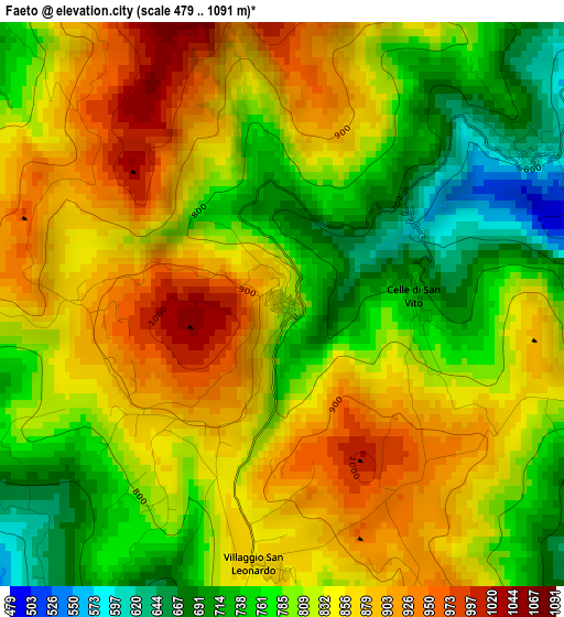
Below is the Elevation map of Faeto, which displays elevation range with different colors. Scale of the first map is from 479 to 1091 m (1572 to 3579 ft) with average elevation of 820.9 meters (=2693 ft) [note 1]
These maps also provides idea of topography and contour of this city, they are displayed at different zoom levels. More info about maps, scale and edge coordinates you can find below images.

| \ | Map #1 | Topo.Map |
| Scale [m] | 479..1091 m | × |
| Scale [ft] | 1572..3579 ft | × |
| Average | 820.9 m = 2693 ft | × |
| Width | 7.34 km = 4.6 mi | 234.8 km = 145.9 mi |
| Height | 7.34 km = 4.6 mi | 234.8 km = 145.9 mi |
| ↑Max Latitude | 41.357884° | 42.37238° |
| Latitude at center | 41.32489° | 41.32489° |
| ↓Min Latitude | 41.29188° | 40.26028° |
| ← Min Longitude | 15.116505° | 13.7542° |
| Longitude center | 15.16045° | 15.16045° |
| →Max Longitude | 15.204395° | 16.5667° |
Nearby cities:
Cities around Faeto sort by population:
• Orsara di Puglia elevation 683 m
10.2 km,  118°
118°
• Biccari 445 m
8.6 km,  20°
20°
• Montefalcone di Val Fortore 840 m
12.6 km,  269°
269°
• Castelluccio Valmaggiore 621 m
3.8 km,  58°
58°
• Roseto Valfortore 724 m
7.7 km,  317°
317°
• Alberona 707 m
12.3 km,  345°
345°
• Savignano Irpino 667 m
11 km,  171°
171°
• Castelfranco in Miscano 759 m
6.8 km,  246°
246°
• Greci 794 m
8.2 km, 174°
• Ginestra degli Schiavoni 533 m
11 km,  242°
242°
• Montaguto 717 m
11.2 km,  139°
139°
• Celle di San Vito 727 m
1.7 km,  86°
86°
Multilingual:
 En español:
Faeto elevación 819 m.
 En France:
Faeto élévation 819 m.


Sources and notes:
- [note 1] Map square and city borders are not equal. Map elevation data is calculated only from area inside that square.
- [src 1] Elevation data from geonames database provided with same terms of usage.
- [src 2] The elevation map of Faeto is generated using elevation data from NASA's 3 arcsec (90m) resolution SRTM data.
- [src 3] Base (background) map © OpenStreetMap contributors tiles are generated by Geofabrik and OpenTopoMap.
Copyright & License:
This Faeto Elevation Map is licensed under CC BY-SA. You may reuse any part from this page, if you give a proper credit by linking to this URL:
 More info on terms of use page.