Fano Adriano elevation
Fano Adriano (Abruzzo, Provincia di Teramo), Italy elevation is 752 meters and Fano Adriano elevation in feet is 2467 ft above sea level [src 1]. Fano Adriano is a seat of a third-order administrative division (feature code) with elevation that is 430 meters (1411 ft) bigger than average city elevation in Italy.
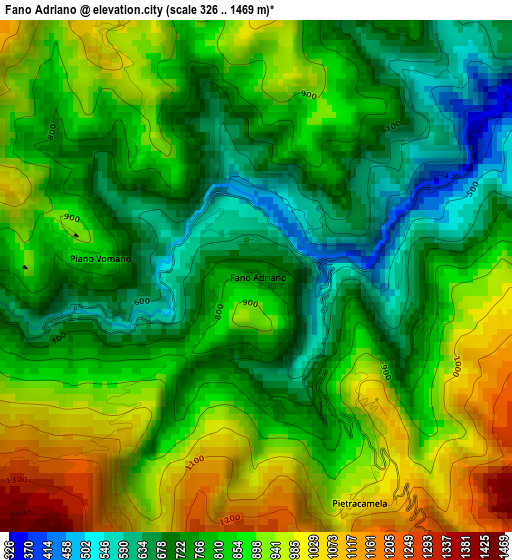
Below is the Elevation map of Fano Adriano, which displays elevation range with different colors. Scale of the first map is from 326 to 1469 m (1070 to 4820 ft) with average elevation of 829.3 meters (=2721 ft) [note 1]
These maps also provides idea of topography and contour of this city, they are displayed at different zoom levels. More info about maps, scale and edge coordinates you can find below images.
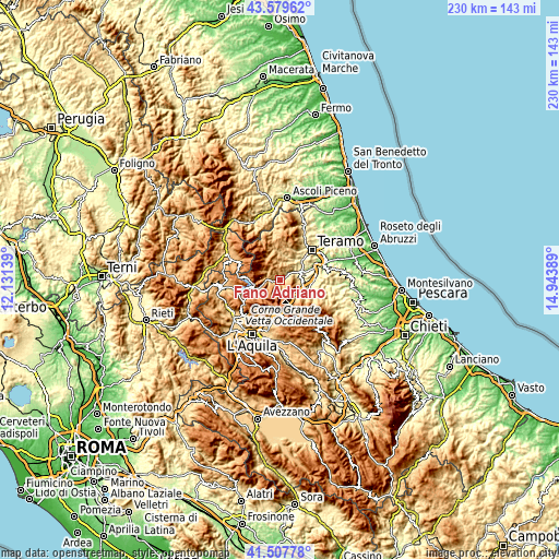
| \ | Map #1 | Topo.Map |
| Scale [m] | 326..1469 m | × |
| Scale [ft] | 1070..4820 ft | × |
| Average | 829.3 m = 2721 ft | × |
| Width | 7.2 km = 4.5 mi | 230.4 km = 143.2 mi |
| Height | 7.2 km = 4.5 mi | 230.4 km = 143.2 mi |
| ↑Max Latitude | 42.584664° | 43.57962° |
| Latitude at center | 42.5523° | 42.5523° |
| ↓Min Latitude | 42.519919° | 41.50778° |
| ← Min Longitude | 13.493695° | 12.13139° |
| Longitude center | 13.53764° | 13.53764° |
| →Max Longitude | 13.581585° | 14.94389° |
Nearby cities:
Cities around Fano Adriano sort by population:
• Montorio al Vomano elevation 248 m
8.8 km,  68°
68°
• Isola del Gran Sasso d'Italia 414 m
11.2 km,  119°
119°
• Torricella 444 m
15.4 km,  39°
39°
• Colledara 417 m
11.4 km,  97°
97°
• Nerito 840 m
4.9 km,  263°
263°
• Tossicia 418 m
8.9 km, 95°
• Campotosto 1407 m
13.9 km,  272°
272°
• Pietracamela 1039 m
3.5 km,  156°
156°
• Imposte 1073 m
14.9 km,  357°
357°
• Cortino 1024 m
8.1 km,  342°
342°
• Castel Castagna 449 m
14.7 km,  94°
94°
• Crognaleto 1078 m
5.6 km,  314°
314°
Multilingual:
 En español:
Fano Adriano elevación 752 m.
 En France:
Fano Adriano élévation 752 m.
 Auf Deutsch:
Fano Adriano höhe über dem Meeresspiegel ist 752 m.

Sources and notes:
- [note 1] Map square and city borders are not equal. Map elevation data is calculated only from area inside that square.
- [src 1] Elevation data from geonames database provided with same terms of usage.
- [src 2] The elevation map of Fano Adriano is generated using elevation data from NASA's 3 arcsec (90m) resolution SRTM data.
- [src 3] Base (background) map © OpenStreetMap contributors tiles are generated by Geofabrik and OpenTopoMap.
Copyright & License:
This Fano Adriano Elevation Map is licensed under CC BY-SA. You may reuse any part from this page, if you give a proper credit by linking to this URL:
 More info on terms of use page.