Torricella elevation
Torricella (Abruzzo, Provincia di Teramo), Italy elevation is 444 meters and Torricella elevation in feet is 1457 ft above sea level [src 1]. Torricella is a seat of a third-order administrative division (feature code) with elevation that is 122 meters (400 ft) bigger than average city elevation in Italy.
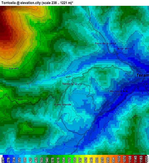
Below is the Elevation map of Torricella, which displays elevation range with different colors. Scale of the first map is from 238 to 1221 m (781 to 4006 ft) with average elevation of 490 meters (=1608 ft) [note 1]
These maps also provides idea of topography and contour of this city, they are displayed at different zoom levels. More info about maps, scale and edge coordinates you can find below images.
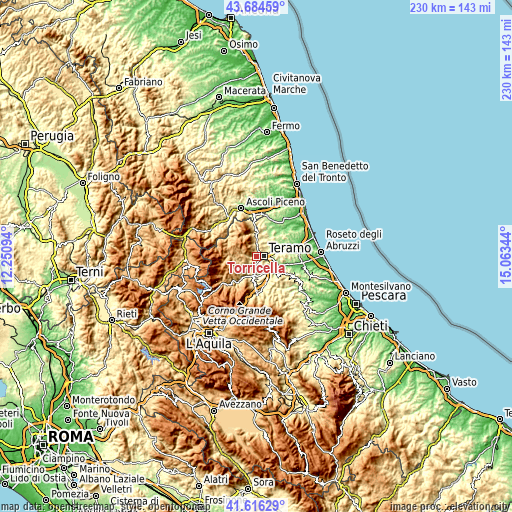
| \ | Map #1 | Topo.Map |
| Scale [m] | 238..1221 m | × |
| Scale [ft] | 781..4006 ft | × |
| Average | 490 m = 1608 ft | × |
| Width | 7.19 km = 4.5 mi | 230 km = 142.9 mi |
| Height | 7.19 km = 4.5 mi | 230 km = 142.9 mi |
| ↑Max Latitude | 42.691349° | 43.68459° |
| Latitude at center | 42.65904° | 42.65904° |
| ↓Min Latitude | 42.626714° | 41.61629° |
| ← Min Longitude | 13.613245° | 12.25094° |
| Longitude center | 13.65719° | 13.65719° |
| →Max Longitude | 13.701135° | 15.06344° |
Nearby cities:
Cities around Torricella sort by population:
• Teramo elevation 280 m
3.4 km,  85°
85°
• Montorio al Vomano 248 m
8.8 km,  190°
190°
• San Nicolò a Tordino 138 m
12.2 km,  69°
69°
• Nepezzano 254 m
8.8 km, 67°
• Civitella del Tronto 529 m
12.8 km,  7°
7°
• Basciano 319 m
9.5 km,  137°
137°
• Canzano 452 m
12.1 km,  97°
97°
• Campli 402 m
7.9 km,  17°
17°
• Penna Sant'Andrea 395 m
11.9 km,  127°
127°
• Tossicia 418 m
12.7 km,  184°
184°
• Imposte 1073 m
11 km,  286°
286°
• Cortino 1024 m
12.9 km,  251°
251°
Multilingual:
 En español:
Torricella elevación 444 m.
 En France:
Torricella Sicura élévation 444 m.
 Auf Deutsch:
Torricella Sicura höhe über dem Meeresspiegel ist 444 m.

Sources and notes:
- [note 1] Map square and city borders are not equal. Map elevation data is calculated only from area inside that square.
- [src 1] Elevation data from geonames database provided with same terms of usage.
- [src 2] The elevation map of Torricella is generated using elevation data from NASA's 3 arcsec (90m) resolution SRTM data.
- [src 3] Base (background) map © OpenStreetMap contributors tiles are generated by Geofabrik and OpenTopoMap.
Copyright & License:
This Torricella Elevation Map is licensed under CC BY-SA. You may reuse any part from this page, if you give a proper credit by linking to this URL:
 More info on terms of use page.