Ferentillo elevation
Ferentillo (Umbria, Provincia di Terni), Italy elevation is 247 meters and Ferentillo elevation in feet is 810 ft above sea level [src 1]. Ferentillo is a seat of a third-order administrative division (feature code) with elevation that is 75 meters (246 ft) smaller than average city elevation in Italy.
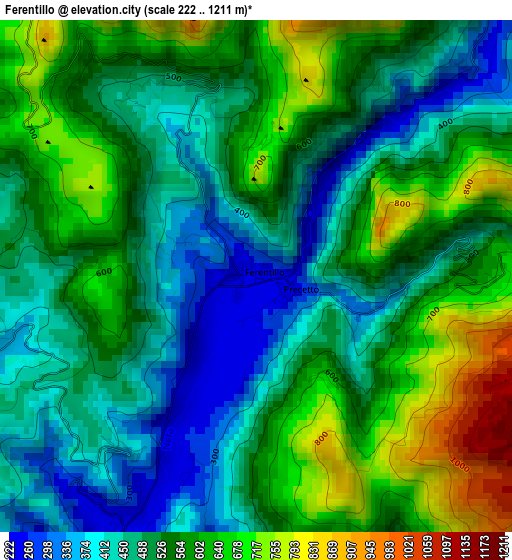
Below is the Elevation map of Ferentillo, which displays elevation range with different colors. Scale of the first map is from 222 to 1211 m (728 to 3973 ft) with average elevation of 536.4 meters (=1760 ft) [note 1]
These maps also provides idea of topography and contour of this city, they are displayed at different zoom levels. More info about maps, scale and edge coordinates you can find below images.
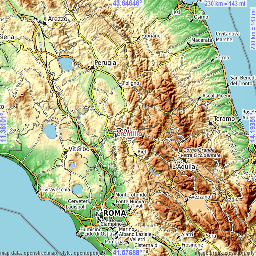
| \ | Map #1 | Topo.Map |
| Scale [m] | 222..1211 m | × |
| Scale [ft] | 728..3973 ft | × |
| Average | 536.4 m = 1760 ft | × |
| Width | 7.19 km = 4.5 mi | 230.1 km = 143 mi |
| Height | 7.19 km = 4.5 mi | 230.1 km = 143 mi |
| ↑Max Latitude | 42.652599° | 43.64646° |
| Latitude at center | 42.62027° | 42.62027° |
| ↓Min Latitude | 42.587924° | 41.57688° |
| ← Min Longitude | 12.743315° | 11.38101° |
| Longitude center | 12.78726° | 12.78726° |
| →Max Longitude | 12.831205° | 14.19351° |
Nearby cities:
Cities around Ferentillo sort by population:
• Terni elevation 127 m
13.4 km,  241°
241°
• Arrone 248 m
4.5 km,  201°
201°
• Montefranco 395 m
3.1 km,  218°
218°
• Colli sul Velino 460 m
13.6 km,  181°
181°
• Monteleone di Spoleto 944 m
13.9 km,  75°
75°
• Scheggino 282 m
10.9 km,  18°
18°
• Sant'Anatolia di Narco 337 m
13.2 km, 17°
• Rivodutri 565 m
12.8 km,  153°
153°
• Polino 838 m
6.2 km,  130°
130°
• Labro 609 m
10.5 km,  174°
174°
• Morro Reatino 769 m
11.6 km,  160°
160°
• Roman catholic diocese of Terni 163 m
13.5 km, 240°
Multilingual:
 En español:
Ferentillo elevación 247 m.
 En France:
Ferentillo élévation 247 m.
 Auf Deutsch:
Ferentillo höhe über dem Meeresspiegel ist 247 m.

Sources and notes:
- [note 1] Map square and city borders are not equal. Map elevation data is calculated only from area inside that square.
- [src 1] Elevation data from geonames database provided with same terms of usage.
- [src 2] The elevation map of Ferentillo is generated using elevation data from NASA's 3 arcsec (90m) resolution SRTM data.
- [src 3] Base (background) map © OpenStreetMap contributors tiles are generated by Geofabrik and OpenTopoMap.
Copyright & License:
This Ferentillo Elevation Map is licensed under CC BY-SA. You may reuse any part from this page, if you give a proper credit by linking to this URL:
 More info on terms of use page.