Polino elevation
Polino (Umbria, Provincia di Terni), Italy elevation is 838 meters and Polino elevation in feet is 2749 ft above sea level [src 1]. Polino is a seat of a third-order administrative division (feature code) with elevation that is 516 meters (1693 ft) bigger than average city elevation in Italy.
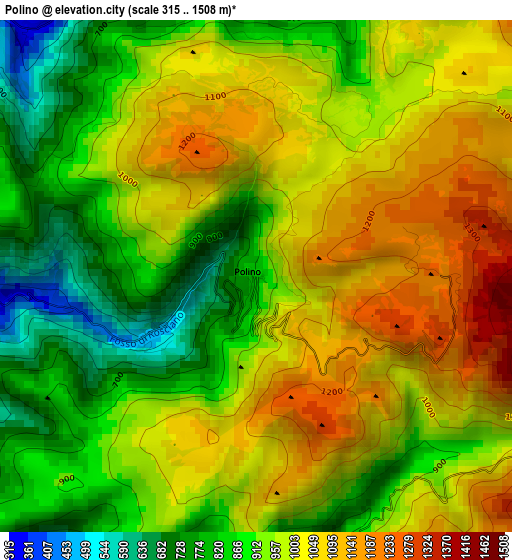
Below is the Elevation map of Polino, which displays elevation range with different colors. Scale of the first map is from 315 to 1508 m (1033 to 4948 ft) with average elevation of 964.7 meters (=3165 ft) [note 1]
These maps also provides idea of topography and contour of this city, they are displayed at different zoom levels. More info about maps, scale and edge coordinates you can find below images.
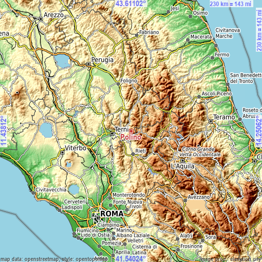
| \ | Map #1 | Topo.Map |
| Scale [m] | 315..1508 m | × |
| Scale [ft] | 1033..4948 ft | × |
| Average | 964.7 m = 3165 ft | × |
| Width | 7.2 km = 4.5 mi | 230.2 km = 143 mi |
| Height | 7.2 km = 4.5 mi | 230.2 km = 143 mi |
| ↑Max Latitude | 42.616578° | 43.61102° |
| Latitude at center | 42.58423° | 42.58423° |
| ↓Min Latitude | 42.551865° | 41.54024° |
| ← Min Longitude | 12.800425° | 11.43812° |
| Longitude center | 12.84437° | 12.84437° |
| →Max Longitude | 12.888315° | 14.25062° |
Nearby cities:
Cities around Polino sort by population:
• Arrone elevation 248 m
6.3 km,  268°
268°
• Ferentillo 247 m
6.2 km,  310°
310°
• Leonessa 953 m
9.6 km,  100°
100°
• Poggio Bustone 750 m
9.6 km,  159°
159°
• Montefranco 395 m
6.8 km,  283°
283°
• Colli sul Velino 460 m
10.9 km,  208°
208°
• Cantalice 728 m
14.2 km, 159°
• Monteleone di Spoleto 944 m
11.5 km,  49°
49°
• Scheggino 282 m
14.4 km,  355°
355°
• Rivodutri 565 m
7.6 km,  172°
172°
• Labro 609 m
7.4 km, 208°
• Morro Reatino 769 m
6.9 km,  186°
186°
Multilingual:
 En español:
Polino elevación 838 m.
 En France:
Polino élévation 838 m.


Sources and notes:
- [note 1] Map square and city borders are not equal. Map elevation data is calculated only from area inside that square.
- [src 1] Elevation data from geonames database provided with same terms of usage.
- [src 2] The elevation map of Polino is generated using elevation data from NASA's 3 arcsec (90m) resolution SRTM data.
- [src 3] Base (background) map © OpenStreetMap contributors tiles are generated by Geofabrik and OpenTopoMap.
Copyright & License:
This Polino Elevation Map is licensed under CC BY-SA. You may reuse any part from this page, if you give a proper credit by linking to this URL:
 More info on terms of use page.