Fermo elevation
Fermo (The Marches, Province of Fermo), Italy elevation is 227 meters and Fermo elevation in feet is 745 ft above sea level [src 1]. Fermo is a seat of a second-order administrative division (feature code) with elevation that is 95 meters (312 ft) smaller than average city elevation in Italy.
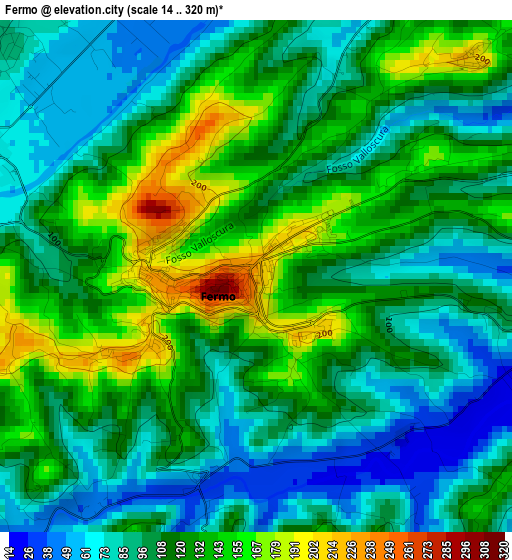
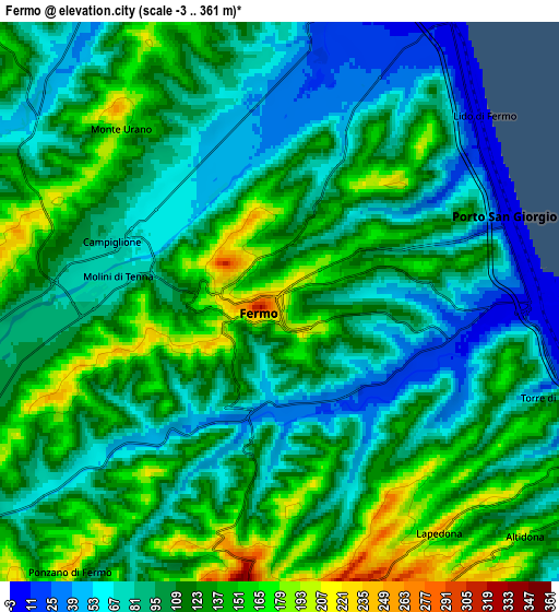
Below is the Elevation map of Fermo, which displays elevation range with different colors. Scale of the first map is from 14 to 320 m (46 to 1050 ft) with average elevation of 112.4 meters (=369 ft) [note 1]
These maps also provides idea of topography and contour of this city, they are displayed at different zoom levels. More info about maps, scale and edge coordinates you can find below images.
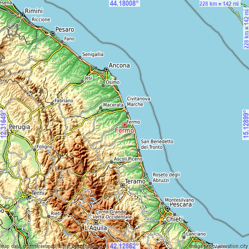
| \ | Map #1 | Map #2 | Topo.Map |
| Scale [m] | 14..320 m | -3..361 m | × |
| Scale [ft] | 46..1050 ft | -10..1184 ft | × |
| Average | 112.4 m = 369 ft | 108.8 m = 357 ft | × |
| Width | 7.13 km = 4.4 mi | 14.26 km = 8.9 mi | 228.1 km = 141.7 mi |
| Height | 7.13 km = 4.4 mi | 14.26 km = 8.9 mi | 228.1 km = 141.7 mi |
| ↑Max Latitude | 43.195006° | 43.227035° | 44.18008° |
| Latitude at center | 43.16296° | 43.16296° | 43.16296° |
| ↓Min Latitude | 43.130897° | 43.098818° | 42.12862° |
| ← Min Longitude | 13.678795° | 13.634849° | 12.31649° |
| Longitude center | 13.72274° | 13.72274° | 13.72274° |
| →Max Longitude | 13.766685° | 13.810631° | 15.12899° |
Nearby cities:
Cities around Fermo sort by population:
• Porto San Giorgio elevation 9 m
6 km,  74°
74°
• Monte Urano 189 m
5.8 km,  301°
301°
• Sant'Elpidio a Mare 224 m
8 km,  339°
339°
• Lido di Fermo 2 m
6.9 km,  46°
46°
• San Tommaso Tre Archi 2 m
8.4 km,  30°
30°
• Campiglione 69 m
4.5 km,  289°
289°
• Capodarco 213 m
4.2 km,  44°
44°
• Monterubbiano 440 m
8.6 km,  181°
181°
• Lapedona 240 m
7.1 km,  146°
146°
• Ponzano di Fermo 231 m
8.3 km,  217°
217°
• Altidona 205 m
8.5 km,  135°
135°
• Moresco 398 m
8.5 km, 175°
Multilingual:
 En español:
Fermo elevación 227 m.
 En France:
Fermo élévation 227 m.


Sources and notes:
- [note 1] Map square and city borders are not equal. Map elevation data is calculated only from area inside that square.
- [src 1] Elevation data from geonames database provided with same terms of usage.
- [src 2] The elevation map of Fermo is generated using elevation data from NASA's 3 arcsec (90m) resolution SRTM data.
- [src 3] Base (background) map © OpenStreetMap contributors tiles are generated by Geofabrik and OpenTopoMap.
Copyright & License:
This Fermo Elevation Map is licensed under CC BY-SA. You may reuse any part from this page, if you give a proper credit by linking to this URL:
 More info on terms of use page.