Monte Urano elevation
Monte Urano (The Marches, Province of Fermo), Italy elevation is 189 meters and Monte Urano elevation in feet is 620 ft above sea level [src 1]. Monte Urano is a seat of a third-order administrative division (feature code) with elevation that is 133 meters (436 ft) smaller than average city elevation in Italy.
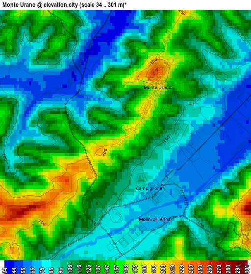
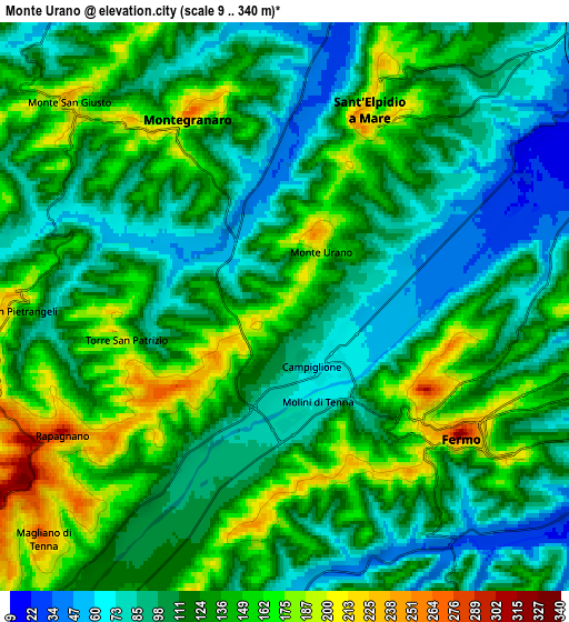
Below is the Elevation map of Monte Urano, which displays elevation range with different colors. Scale of the first map is from 34 to 301 m (112 to 988 ft) with average elevation of 115.4 meters (=379 ft) [note 1]
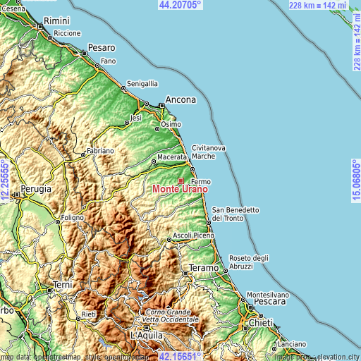
These maps also provides idea of topography and contour of this city, they are displayed at different zoom levels. More info about maps, scale and edge coordinates you can find below images.
| \ | Map #1 | Map #2 | Topo.Map |
| Scale [m] | 34..301 m | 9..340 m | × |
| Scale [ft] | 112..988 ft | 30..1115 ft | × |
| Average | 115.4 m = 379 ft | 121.5 m = 399 ft | × |
| Width | 7.12 km = 4.4 mi | 14.25 km = 8.9 mi | 228 km = 141.7 mi |
| Height | 7.12 km = 4.4 mi | 14.25 km = 8.9 mi | 228 km = 141.7 mi |
| ↑Max Latitude | 43.222421° | 43.254436° | 44.20705° |
| Latitude at center | 43.19039° | 43.19039° | 43.19039° |
| ↓Min Latitude | 43.158342° | 43.126277° | 42.15651° |
| ← Min Longitude | 13.617855° | 13.573909° | 12.25555° |
| Longitude center | 13.6618° | 13.6618° | 13.6618° |
| →Max Longitude | 13.705745° | 13.749691° | 15.06805° |
Nearby cities:
Cities around Monte Urano sort by population:
• Fermo elevation 227 m
5.8 km,  121°
121°
• Montegranaro 207 m
5.2 km,  330°
330°
• Monte San Giusto 224 m
7.5 km,  312°
312°
• Sant'Elpidio a Mare 224 m
4.9 km,  25°
25°
• Casette d'Ete 34 m
7.3 km,  13°
13°
• Grottazzolina 133 m
9.1 km,  209°
209°
• Monte San Pietrangeli 198 m
6.9 km,  269°
269°
• Torre San Patrizio 190 m
4.2 km,  258°
258°
• Campiglione 69 m
1.7 km,  155°
155°
• Capodarco 213 m
7.9 km,  90°
90°
• Rapagnano 295 m
6.8 km,  240°
240°
• Magliano di Tenna 262 m
8.4 km,  226°
226°
Multilingual:
 En español:
Monte Urano elevación 189 m.
 En France:
Monte Urano élévation 189 m.
 Auf Deutsch:
Monte Urano höhe über dem Meeresspiegel ist 189 m.

Sources and notes:
- [note 1] Map square and city borders are not equal. Map elevation data is calculated only from area inside that square.
- [src 1] Elevation data from geonames database provided with same terms of usage.
- [src 2] The elevation map of Monte Urano is generated using elevation data from NASA's 3 arcsec (90m) resolution SRTM data.
- [src 3] Base (background) map © OpenStreetMap contributors tiles are generated by Geofabrik and OpenTopoMap.
Copyright & License:
This Monte Urano Elevation Map is licensed under CC BY-SA. You may reuse any part from this page, if you give a proper credit by linking to this URL:
 More info on terms of use page.