Fognano elevation
Fognano (Emilia-Romagna, Provincia di Ravenna), Italy elevation is 128 meters and Fognano elevation in feet is 420 ft above sea level [src 1]. Fognano is a populated place (feature code) with elevation that is 194 meters (636 ft) smaller than average city elevation in Italy.
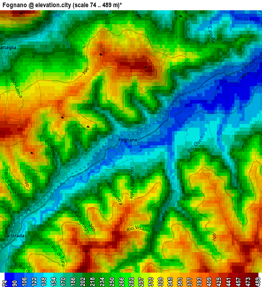
Below is the Elevation map of Fognano, which displays elevation range with different colors. Scale of the first map is from 74 to 489 m (243 to 1604 ft) with average elevation of 253.4 meters (=831 ft) [note 1]
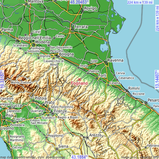
These maps also provides idea of topography and contour of this city, they are displayed at different zoom levels. More info about maps, scale and edge coordinates you can find below images.
| \ | Map #1 | Topo.Map |
| Scale [m] | 74..489 m | × |
| Scale [ft] | 243..1604 ft | × |
| Average | 253.4 m = 831 ft | × |
| Width | 7.01 km = 4.4 mi | 224.2 km = 139.3 mi |
| Height | 7.01 km = 4.4 mi | 224.2 km = 139.3 mi |
| ↑Max Latitude | 44.236584° | 45.20453° |
| Latitude at center | 44.20509° | 44.20509° |
| ↓Min Latitude | 44.173579° | 43.1884° |
| ← Min Longitude | 11.693875° | 10.33157° |
| Longitude center | 11.73782° | 11.73782° |
| →Max Longitude | 11.781765° | 13.14407° |
Nearby cities:
Cities around Fognano sort by population:
• Faenza elevation 41 m
14.7 km,  50°
50°
• Castel Bolognese 46 m
13.7 km,  20°
20°
• Riolo Terme 93 m
7.9 km,  353°
353°
• Modigliana 167 m
6.7 km,  139°
139°
• Brisighella 116 m
3.4 km,  56°
56°
• Borgo Tossignano 94 m
14.2 km,  307°
307°
• Casalfiumanese 88 m
13.6 km,  318°
318°
• Casola Valsenio 200 m
9.3 km,  283°
283°
• Fontanelice 170 m
15.5 km,  292°
292°
• Dovadola 132 m
15.1 km,  127°
127°
• Tredozio 346 m
14 km,  178°
178°
• Castrocaro Terme 72 m
17.2 km,  101°
101°
Multilingual:
 En español:
Fognano elevación 128 m.
 En France:
Fognano élévation 128 m.


Sources and notes:
- [note 1] Map square and city borders are not equal. Map elevation data is calculated only from area inside that square.
- [src 1] Elevation data from geonames database provided with same terms of usage.
- [src 2] The elevation map of Fognano is generated using elevation data from NASA's 3 arcsec (90m) resolution SRTM data.
- [src 3] Base (background) map © OpenStreetMap contributors tiles are generated by Geofabrik and OpenTopoMap.
Copyright & License:
This Fognano Elevation Map is licensed under CC BY-SA. You may reuse any part from this page, if you give a proper credit by linking to this URL:
 More info on terms of use page.