Fontanellato elevation
Fontanellato (Emilia-Romagna, Provincia di Parma), Italy elevation is 44 meters and Fontanellato elevation in feet is 144 ft above sea level [src 1]. Fontanellato is a seat of a third-order administrative division (feature code) with elevation that is 278 meters (912 ft) smaller than average city elevation in Italy.
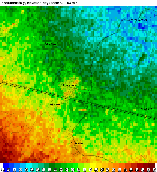
Below is the Elevation map of Fontanellato, which displays elevation range with different colors. Scale of the first map is from 30 to 63 m (98 to 207 ft) with average elevation of 44.7 meters (=147 ft) [note 1]
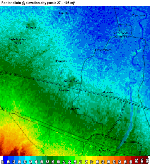
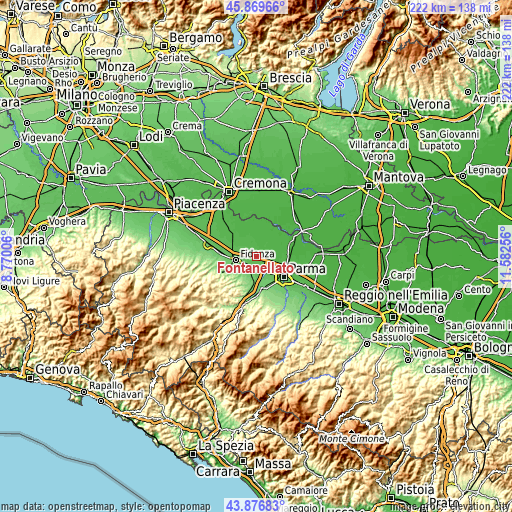
These maps also provides idea of topography and contour of this city, they are displayed at different zoom levels. More info about maps, scale and edge coordinates you can find below images.
| \ | Map #1 | Map #2 | Topo.Map |
| Scale [m] | 30..63 m | 27..108 m | × |
| Scale [ft] | 98..207 ft | 89..354 ft | × |
| Average | 44.7 m = 147 ft | 48.2 m = 158 ft | × |
| Width | 6.92 km = 4.3 mi | 13.85 km = 8.6 mi | 221.6 km = 137.7 mi |
| Height | 6.92 km = 4.3 mi | 13.85 km = 8.6 mi | 221.6 km = 137.7 mi |
| ↑Max Latitude | 44.913° | 44.944112° | 45.86966° |
| Latitude at center | 44.88187° | 44.88187° | 44.88187° |
| ↓Min Latitude | 44.850724° | 44.81956° | 43.87683° |
| ← Min Longitude | 10.132365° | 10.088419° | 8.77006° |
| Longitude center | 10.17631° | 10.17631° | 10.17631° |
| →Max Longitude | 10.220255° | 10.264201° | 11.58256° |
Nearby cities:
Cities around Fontanellato sort by population:
• Fidenza elevation 81 m
9.3 km,  259°
259°
• Noceto 77 m
8 km,  179°
179°
• San Secondo Parmense 39 m
6.2 km,  43°
43°
• Medesano 135 m
14.1 km,  192°
192°
• Soragna 46 m
6.7 km,  318°
318°
• Ponte Taro 61 m
6.5 km,  155°
155°
• Baganzola 42 m
10.7 km,  106°
106°
• Trecasali 33 m
9.8 km,  50°
50°
• Sissa 31 m
10.9 km, 37°
• Vicofertile 79 m
12.7 km,  147°
147°
• Fontevivo 53 m
2.5 km, 186°
• Torrile 29 m
12.6 km,  67°
67°
Multilingual:
 En español:
Fontanellato elevación 44 m.
 En France:
Fontanellato élévation 44 m.
 Auf Deutsch:
Fontanellato höhe über dem Meeresspiegel ist 44 m.

Sources and notes:
- [note 1] Map square and city borders are not equal. Map elevation data is calculated only from area inside that square.
- [src 1] Elevation data from geonames database provided with same terms of usage.
- [src 2] The elevation map of Fontanellato is generated using elevation data from NASA's 3 arcsec (90m) resolution SRTM data.
- [src 3] Base (background) map © OpenStreetMap contributors tiles are generated by Geofabrik and OpenTopoMap.
Copyright & License:
This Fontanellato Elevation Map is licensed under CC BY-SA. You may reuse any part from this page, if you give a proper credit by linking to this URL:
 More info on terms of use page.