Medesano elevation
Medesano (Emilia-Romagna, Provincia di Parma), Italy elevation is 135 meters and Medesano elevation in feet is 443 ft above sea level [src 1]. Medesano is a seat of a third-order administrative division (feature code) with elevation that is 187 meters (614 ft) smaller than average city elevation in Italy.
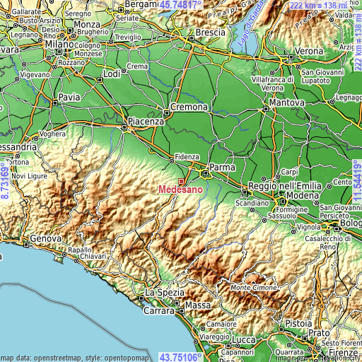
Below is the Elevation map of Medesano, which displays elevation range with different colors. Scale of the first map is from 76 to 297 m (249 to 974 ft) with average elevation of 136.2 meters (=447 ft) [note 1]
These maps also provides idea of topography and contour of this city, they are displayed at different zoom levels. More info about maps, scale and edge coordinates you can find below images.

| \ | Map #1 | Topo.Map |
| Scale [m] | 76..297 m | × |
| Scale [ft] | 249..974 ft | × |
| Average | 136.2 m = 447 ft | × |
| Width | 6.94 km = 4.3 mi | 222.1 km = 138 mi |
| Height | 6.94 km = 4.3 mi | 222 km = 137.9 mi |
| ↑Max Latitude | 44.789436° | 45.74817° |
| Latitude at center | 44.75824° | 44.75824° |
| ↓Min Latitude | 44.727027° | 43.75106° |
| ← Min Longitude | 10.093995° | 8.73169° |
| Longitude center | 10.13794° | 10.13794° |
| →Max Longitude | 10.181885° | 11.54419° |
Nearby cities:
Cities around Medesano sort by population:
• Noceto elevation 77 m
6.5 km,  28°
28°
• Collecchio 116 m
6.2 km,  96°
96°
• Sala Baganza 169 m
8.4 km,  124°
124°
• Felino 181 m
10.3 km,  129°
129°
• Fornovo di Taro 136 m
7.6 km,  201°
201°
• Felegara 128 m
4.5 km,  206°
206°
• Ponte Taro 61 m
9.7 km,  36°
36°
• Vicofertile 79 m
10.3 km,  72°
72°
• Ramiola 156 m
7.4 km, 209°
• Riccò 139 m
6.6 km,  191°
191°
• Ozzano Taro 136 m
5.4 km,  177°
177°
• Gaiano 118 m
4.7 km,  144°
144°
Multilingual:
 En español:
Medesano elevación 135 m.
 En France:
Medesano élévation 135 m.
 Auf Deutsch:
Medesano höhe über dem Meeresspiegel ist 135 m.

Sources and notes:
- [note 1] Map square and city borders are not equal. Map elevation data is calculated only from area inside that square.
- [src 1] Elevation data from geonames database provided with same terms of usage.
- [src 2] The elevation map of Medesano is generated using elevation data from NASA's 3 arcsec (90m) resolution SRTM data.
- [src 3] Base (background) map © OpenStreetMap contributors tiles are generated by Geofabrik and OpenTopoMap.
Copyright & License:
This Medesano Elevation Map is licensed under CC BY-SA. You may reuse any part from this page, if you give a proper credit by linking to this URL:
 More info on terms of use page.