Francavilla Fontana elevation
Francavilla Fontana (Apulia, Provincia di Brindisi), Italy elevation is 146 meters and Francavilla Fontana elevation in feet is 479 ft above sea level [src 1]. Francavilla Fontana is a seat of a third-order administrative division (feature code) with elevation that is 176 meters (577 ft) smaller than average city elevation in Italy.
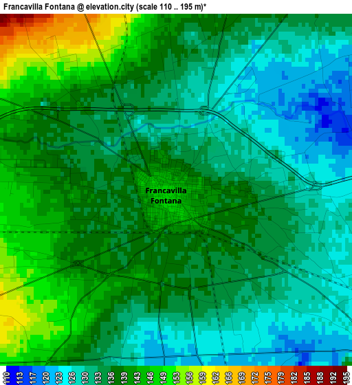
Below is the Elevation map of Francavilla Fontana, which displays elevation range with different colors. Scale of the first map is from 110 to 195 m (361 to 640 ft) with average elevation of 136.2 meters (=447 ft) [note 1]
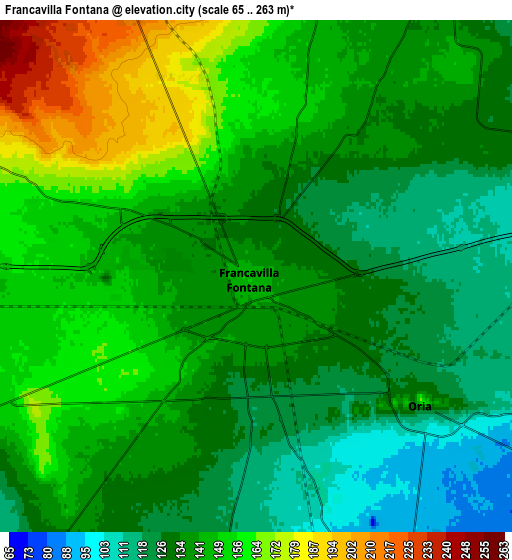
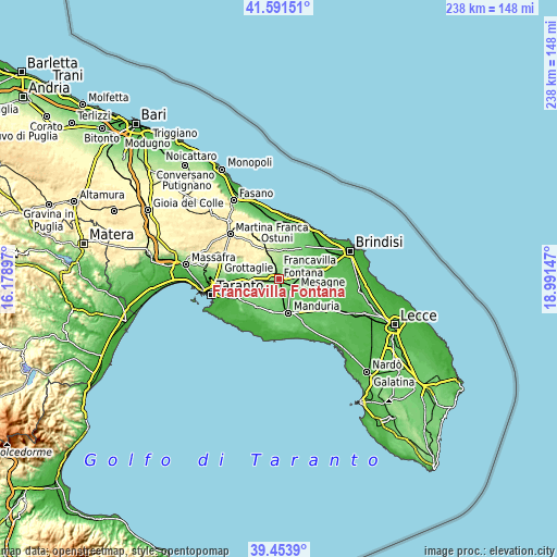
These maps also provides idea of topography and contour of this city, they are displayed at different zoom levels. More info about maps, scale and edge coordinates you can find below images.
| \ | Map #1 | Map #2 | Topo.Map |
| Scale [m] | 110..195 m | 65..263 m | × |
| Scale [ft] | 361..640 ft | 213..863 ft | × |
| Average | 136.2 m = 447 ft | 140.9 m = 462 ft | × |
| Width | 7.43 km = 4.6 mi | 14.86 km = 9.2 mi | 237.7 km = 147.7 mi |
| Height | 7.43 km = 4.6 mi | 14.86 km = 9.2 mi | 237.7 km = 147.7 mi |
| ↑Max Latitude | 40.564622° | 40.597998° | 41.59151° |
| Latitude at center | 40.53123° | 40.53123° | 40.53123° |
| ↓Min Latitude | 40.497821° | 40.464395° | 39.4539° |
| ← Min Longitude | 17.541275° | 17.497329° | 16.17897° |
| Longitude center | 17.58522° | 17.58522° | 17.58522° |
| →Max Longitude | 17.629165° | 17.673111° | 18.99147° |
Nearby cities:
Cities around Francavilla Fontana sort by population:
• Grottaglie elevation 140 m
12.5 km,  272°
272°
• Manduria 86 m
15.3 km,  163°
163°
• Ceglie Messapica 301 m
14 km,  335°
335°
• Sava 111 m
14.6 km,  190°
190°
• Oria 147 m
6 km,  125°
125°
• Latiano 102 m
11.5 km,  79°
79°
• Torre Santa Susanna 71 m
14.8 km,  118°
118°
• San Marzano di San Giuseppe 134 m
11 km,  219°
219°
• Villa Castelli 270 m
11 km,  301°
301°
• San Michele Salentino 153 m
11.9 km,  19°
19°
• Fragagnano 101 m
14.6 km, 219°
• Uggiano Montefusco 97 m
16.2 km,  174°
174°
Multilingual:
 En español:
Francavilla Fontana elevación 146 m.
 En France:
Francavilla Fontana élévation 146 m.
 Auf Deutsch:
Francavilla Fontana höhe über dem Meeresspiegel ist 146 m.
 На русском:
Francavilla Fontana высота над уровнем моря 146 м
Sources and notes:
- [note 1] Map square and city borders are not equal. Map elevation data is calculated only from area inside that square.
- [src 1] Elevation data from geonames database provided with same terms of usage.
- [src 2] The elevation map of Francavilla Fontana is generated using elevation data from NASA's 3 arcsec (90m) resolution SRTM data.
- [src 3] Base (background) map © OpenStreetMap contributors tiles are generated by Geofabrik and OpenTopoMap.
Copyright & License:
This Francavilla Fontana Elevation Map is licensed under CC BY-SA. You may reuse any part from this page, if you give a proper credit by linking to this URL:
 More info on terms of use page.