Gaeta elevation
Gaeta (Latium, Provincia di Latina), Italy elevation is 9 meters and Gaeta elevation in feet is 30 ft above sea level [src 1]. Gaeta is a seat of a third-order administrative division (feature code) with elevation that is 313 meters (1027 ft) smaller than average city elevation in Italy.
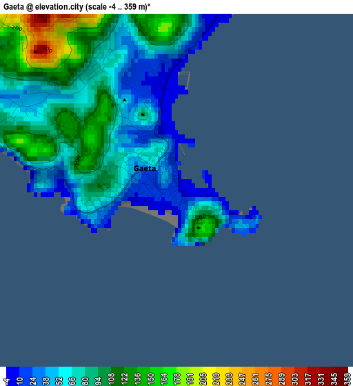
Below is the Elevation map of Gaeta, which displays elevation range with different colors. Scale of the first map is from -4 to 359 m (-13 to 1178 ft) with average elevation of 80.8 meters (=265 ft) [note 1]
These maps also provides idea of topography and contour of this city, they are displayed at different zoom levels. More info about maps, scale and edge coordinates you can find below images.
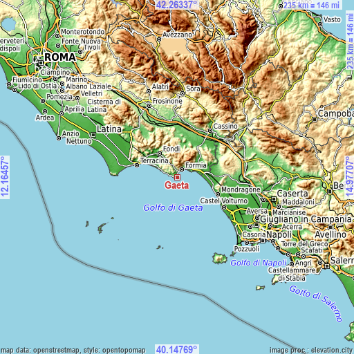
| \ | Map #1 | Map #2 | Topo.Map |
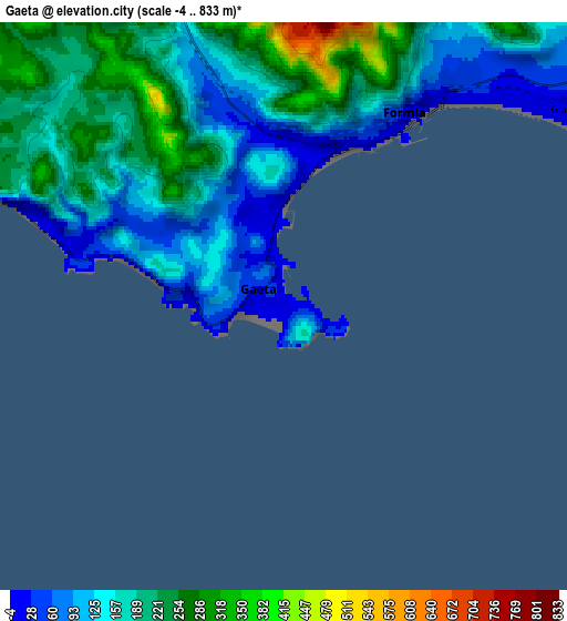
| Scale [m] | -4..359 m | -4..833 m | × |
| Scale [ft] | -13..1178 ft | -13..2733 ft | × |
| Average | 80.8 m = 265 ft | 167.6 m = 550 ft | × |
| Width | 7.35 km = 4.6 mi | 14.7 km = 9.1 mi | 235.2 km = 146.1 mi |
| Height | 7.35 km = 4.6 mi | 14.7 km = 9.1 mi | 235.2 km = 146.1 mi |
| ↑Max Latitude | 41.24713° | 41.280163° | 42.26337° |
| Latitude at center | 41.21408° | 41.21408° | 41.21408° |
| ↓Min Latitude | 41.181014° | 41.147931° | 40.14769° |
| ← Min Longitude | 13.526875° | 13.482929° | 12.16457° |
| Longitude center | 13.57082° | 13.57082° | 13.57082° |
| →Max Longitude | 13.614765° | 13.658711° | 14.97707° |
Nearby cities:
Cities around Gaeta sort by population:
• Formia elevation 8 m
5.7 km,  34°
34°
• Fondi 18 m
20 km,  323°
323°
• Minturno 128 m
15.6 km,  69°
69°
• Itri 174 m
9.1 km,  338°
338°
• Grunuovo-Campomaggiore San Luca 15 m
20.8 km, 71°
• Sperlonga 10 m
12.6 km,  293°
293°
• Maranola-Trivio 233 m
9.2 km, 31°
• Penitro 40 m
12.1 km,  57°
57°
• Spigno Saturnia Inferiore 53 m
17.6 km,  52°
52°
• Esperia 330 m
21 km, 26°
• Campodimele 615 m
19.6 km,  350°
350°
• Spigno Saturnia Superiore 356 m
16 km, 46°
Multilingual:
 En español:
Gaeta elevación 9 m.
 En France:
Gaète élévation 9 m.


Sources and notes:
- [note 1] Map square and city borders are not equal. Map elevation data is calculated only from area inside that square.
- [src 1] Elevation data from geonames database provided with same terms of usage.
- [src 2] The elevation map of Gaeta is generated using elevation data from NASA's 3 arcsec (90m) resolution SRTM data.
- [src 3] Base (background) map © OpenStreetMap contributors tiles are generated by Geofabrik and OpenTopoMap.
Copyright & License:
This Gaeta Elevation Map is licensed under CC BY-SA. You may reuse any part from this page, if you give a proper credit by linking to this URL:
 More info on terms of use page.