Gambolò elevation
Gambolò (Lombardy, Provincia di Pavia), Italy elevation is 104 meters and Gambolò elevation in feet is 341 ft above sea level [src 1]. Gambolò is a seat of a third-order administrative division (feature code) with elevation that is 218 meters (715 ft) smaller than average city elevation in Italy.
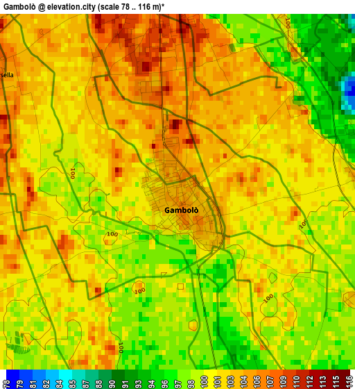
Below is the Elevation map of Gambolò, which displays elevation range with different colors. Scale of the first map is from 78 to 116 m (256 to 381 ft) with average elevation of 101.1 meters (=332 ft) [note 1]
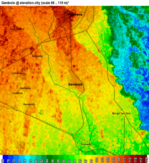
These maps also provides idea of topography and contour of this city, they are displayed at different zoom levels. More info about maps, scale and edge coordinates you can find below images.
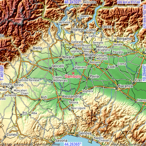
| \ | Map #1 | Map #2 | Topo.Map |
| Scale [m] | 78..116 m | 68..119 m | × |
| Scale [ft] | 256..381 ft | 223..390 ft | × |
| Average | 101.1 m = 332 ft | 97.5 m = 320 ft | × |
| Width | 6.88 km = 4.3 mi | 13.76 km = 8.6 mi | 220.1 km = 136.8 mi |
| Height | 6.88 km = 4.3 mi | 13.76 km = 8.6 mi | 220.1 km = 136.8 mi |
| ↑Max Latitude | 45.293013° | 45.323919° | 46.24327° |
| Latitude at center | 45.26209° | 45.26209° | 45.26209° |
| ↓Min Latitude | 45.23115° | 45.200193° | 44.26365° |
| ← Min Longitude | 8.814255° | 8.770309° | 7.45195° |
| Longitude center | 8.8582° | 8.8582° | 8.8582° |
| →Max Longitude | 8.902145° | 8.946091° | 10.26445° |
Nearby cities:
Cities around Gambolò sort by population:
• Vigevano elevation 112 m
5.8 km,  357°
357°
• Mortara 111 m
9.9 km,  261°
261°
• Garlasco 95 m
9 km,  145°
145°
• Motta Visconti 100 m
10.9 km,  74°
74°
• Cilavegna 116 m
10.4 km,  301°
301°
• Tromello 96 m
6 km,  170°
170°
• Gravellona 115 m
10.4 km,  314°
314°
• Besate 101 m
10.4 km,  57°
57°
• Parona 110 m
8.7 km,  284°
284°
• Alagna 93 m
10.6 km, 166°
• Cergnago 104 m
9.8 km,  223°
223°
• Borgo San Siro 99 m
5.3 km,  124°
124°
Multilingual:
 En español:
Gambolò elevación 104 m.
 En France:
Gambolò élévation 104 m.


Sources and notes:
- [note 1] Map square and city borders are not equal. Map elevation data is calculated only from area inside that square.
- [src 1] Elevation data from geonames database provided with same terms of usage.
- [src 2] The elevation map of Gambolò is generated using elevation data from NASA's 3 arcsec (90m) resolution SRTM data.
- [src 3] Base (background) map © OpenStreetMap contributors tiles are generated by Geofabrik and OpenTopoMap.
Copyright & License:
This Gambolò Elevation Map is licensed under CC BY-SA. You may reuse any part from this page, if you give a proper credit by linking to this URL:
 More info on terms of use page.