Parona elevation
Parona (Lombardy, Provincia di Pavia), Italy elevation is 110 meters and Parona elevation in feet is 361 ft above sea level [src 1]. Parona is a seat of a third-order administrative division (feature code) with elevation that is 212 meters (696 ft) smaller than average city elevation in Italy.
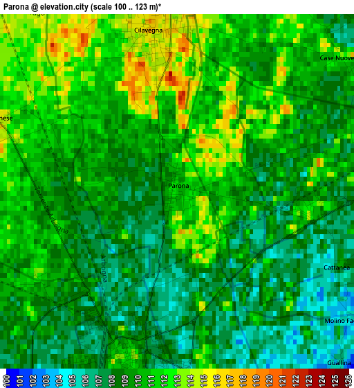
Below is the Elevation map of Parona, which displays elevation range with different colors. Scale of the first map is from 100 to 123 m (328 to 404 ft) with average elevation of 109.5 meters (=359 ft) [note 1]
These maps also provides idea of topography and contour of this city, they are displayed at different zoom levels. More info about maps, scale and edge coordinates you can find below images.
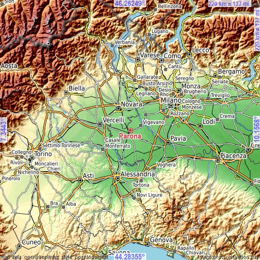
| \ | Map #1 | Topo.Map |
| Scale [m] | 100..123 m | × |
| Scale [ft] | 328..404 ft | × |
| Average | 109.5 m = 359 ft | × |
| Width | 6.88 km = 4.3 mi | 220 km = 136.7 mi |
| Height | 6.88 km = 4.3 mi | 220 km = 136.7 mi |
| ↑Max Latitude | 45.312562° | 46.26249° |
| Latitude at center | 45.28165° | 45.28165° |
| ↓Min Latitude | 45.250721° | 44.28355° |
| ← Min Longitude | 8.706605° | 7.3443° |
| Longitude center | 8.75055° | 8.75055° |
| →Max Longitude | 8.794495° | 10.1568° |
Nearby cities:
Cities around Parona sort by population:
• Vigevano elevation 112 m
8.9 km,  66°
66°
• Mortara 111 m
3.8 km,  200°
200°
• Gambolò 104 m
8.7 km,  104°
104°
• Cilavegna 116 m
3.3 km,  351°
351°
• Gravellona 115 m
5.2 km,  11°
11°
• Borgolavezzaro 119 m
5.8 km,  316°
316°
• Castello d'Agogna 106 m
7.2 km,  223°
223°
• Tornaco 123 m
8.7 km,  342°
342°
• Olevano di Lomellina 106 m
8 km, 198°
• Albonese 115 m
3.7 km,  289°
289°
• Nicorvo 115 m
6.5 km,  273°
273°
• Ceretto Lomellina 111 m
7.3 km,  236°
236°
Multilingual:
 En español:
Parona elevación 110 m.
 En France:
Parona élévation 110 m.


Sources and notes:
- [note 1] Map square and city borders are not equal. Map elevation data is calculated only from area inside that square.
- [src 1] Elevation data from geonames database provided with same terms of usage.
- [src 2] The elevation map of Parona is generated using elevation data from NASA's 3 arcsec (90m) resolution SRTM data.
- [src 3] Base (background) map © OpenStreetMap contributors tiles are generated by Geofabrik and OpenTopoMap.
Copyright & License:
This Parona Elevation Map is licensed under CC BY-SA. You may reuse any part from this page, if you give a proper credit by linking to this URL:
 More info on terms of use page.