Garda elevation
Garda (Veneto, Provincia di Verona), Italy elevation is 92 meters and Garda elevation in feet is 302 ft above sea level [src 1]. Garda is a seat of a third-order administrative division (feature code) with elevation that is 230 meters (755 ft) smaller than average city elevation in Italy.
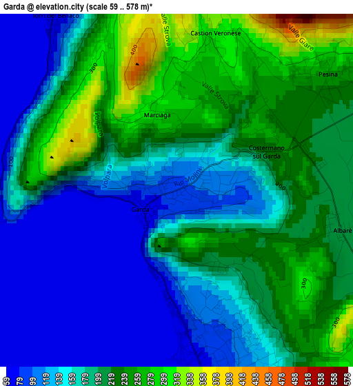
Below is the Elevation map of Garda, which displays elevation range with different colors. Scale of the first map is from 59 to 578 m (194 to 1896 ft) with average elevation of 184.9 meters (=607 ft) [note 1]
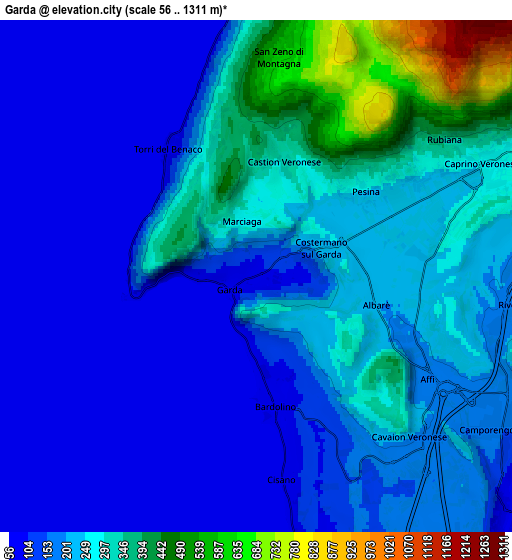
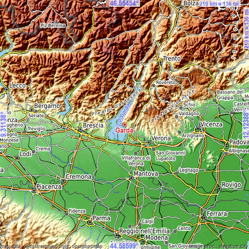
These maps also provides idea of topography and contour of this city, they are displayed at different zoom levels. More info about maps, scale and edge coordinates you can find below images.
| \ | Map #1 | Map #2 | Topo.Map |
| Scale [m] | 59..578 m | 56..1311 m | × |
| Scale [ft] | 194..1896 ft | 184..4301 ft | × |
| Average | 184.9 m = 607 ft | 210.9 m = 692 ft | × |
| Width | 6.84 km = 4.3 mi | 13.68 km = 8.5 mi | 218.9 km = 136 mi |
| Height | 6.84 km = 4.3 mi | 13.68 km = 8.5 mi | 218.9 km = 136 mi |
| ↑Max Latitude | 45.60964° | 45.640373° | 46.55454° |
| Latitude at center | 45.57889° | 45.57889° | 45.57889° |
| ↓Min Latitude | 45.548123° | 45.517339° | 44.58599° |
| ← Min Longitude | 10.673685° | 10.629739° | 9.31138° |
| Longitude center | 10.71763° | 10.71763° | 10.71763° |
| →Max Longitude | 10.761575° | 10.805521° | 12.12388° |
Nearby cities:
Cities around Garda sort by population:
• Bardolino elevation 119 m
4.4 km,  164°
164°
• Caprino Veronese 256 m
6.7 km,  64°
64°
• Cavajon Veronese 211 m
6 km,  136°
136°
• Lazise 86 m
8.4 km,  168°
168°
• Torri del Benaco 72 m
4.2 km,  325°
325°
• Affi 193 m
6.1 km,  118°
118°
• San Zeno di Montagna 599 m
6.6 km,  9°
9°
• Volargne 108 m
9.1 km, 120°
• San Zeno 588 m
6.2 km, 9°
• Calmasino 154 m
7 km, 157°
• Costermano 227 m
1.8 km, 64°
• Rivoli Veronese 194 m
7.4 km,  95°
95°
Multilingual:
 En español:
Garda elevación 92 m.
 En France:
Garda élévation 92 m.


Sources and notes:
- [note 1] Map square and city borders are not equal. Map elevation data is calculated only from area inside that square.
- [src 1] Elevation data from geonames database provided with same terms of usage.
- [src 2] The elevation map of Garda is generated using elevation data from NASA's 3 arcsec (90m) resolution SRTM data.
- [src 3] Base (background) map © OpenStreetMap contributors tiles are generated by Geofabrik and OpenTopoMap.
Copyright & License:
This Garda Elevation Map is licensed under CC BY-SA. You may reuse any part from this page, if you give a proper credit by linking to this URL:
 More info on terms of use page.