Volargne elevation
Volargne (Veneto, Provincia di Verona), Italy elevation is 108 meters and Volargne elevation in feet is 354 ft above sea level [src 1]. Volargne is a populated place (feature code) with elevation that is 214 meters (702 ft) smaller than average city elevation in Italy.
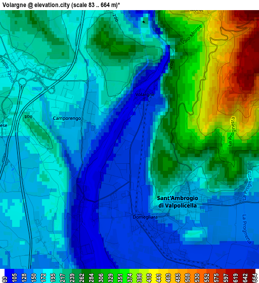
Below is the Elevation map of Volargne, which displays elevation range with different colors. Scale of the first map is from 83 to 664 m (272 to 2178 ft) with average elevation of 214.6 meters (=704 ft) [note 1]
These maps also provides idea of topography and contour of this city, they are displayed at different zoom levels. More info about maps, scale and edge coordinates you can find below images.
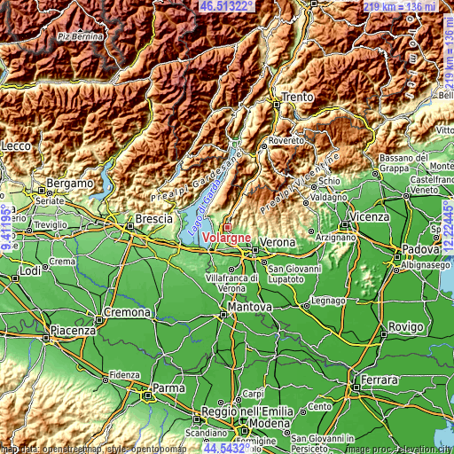
| \ | Map #1 | Topo.Map |
| Scale [m] | 83..664 m | × |
| Scale [ft] | 272..2178 ft | × |
| Average | 214.6 m = 704 ft | × |
| Width | 6.85 km = 4.3 mi | 219 km = 136.1 mi |
| Height | 6.85 km = 4.3 mi | 219 km = 136.1 mi |
| ↑Max Latitude | 45.567613° | 46.51322° |
| Latitude at center | 45.53684° | 45.53684° |
| ↓Min Latitude | 45.50605° | 44.5432° |
| ← Min Longitude | 10.774255° | 9.41195° |
| Longitude center | 10.8182° | 10.8182° |
| →Max Longitude | 10.862145° | 12.22445° |
Nearby cities:
Cities around Volargne sort by population:
• Pescantina elevation 92 m
6.9 km,  145°
145°
• Sant'Ambrogio di Valpollicella 158 m
2.3 km,  141°
141°
• San Pietro in Cariano 157 m
5.7 km,  112°
112°
• Bardolino 119 m
6.7 km,  274°
274°
• Cavajon Veronese 211 m
3.7 km,  275°
275°
• Lazise 86 m
7.1 km,  240°
240°
• Fumane 181 m
5.3 km,  84°
84°
• Pastrengo 184 m
4.8 km,  198°
198°
• Affi 193 m
3.1 km,  305°
305°
• Ospedaletto 122 m
4 km, 152°
• Calmasino 154 m
5.4 km,  251°
251°
• Rivoli Veronese 194 m
4 km,  352°
352°
Multilingual:
 En español:
Volargne elevación 108 m.
 En France:
Volargne élévation 108 m.
 Auf Deutsch:
Volargne höhe über dem Meeresspiegel ist 108 m.

Sources and notes:
- [note 1] Map square and city borders are not equal. Map elevation data is calculated only from area inside that square.
- [src 1] Elevation data from geonames database provided with same terms of usage.
- [src 2] The elevation map of Volargne is generated using elevation data from NASA's 3 arcsec (90m) resolution SRTM data.
- [src 3] Base (background) map © OpenStreetMap contributors tiles are generated by Geofabrik and OpenTopoMap.
Copyright & License:
This Volargne Elevation Map is licensed under CC BY-SA. You may reuse any part from this page, if you give a proper credit by linking to this URL:
 More info on terms of use page.