Ghemme elevation
Ghemme (Piedmont, Provincia di Novara), Italy elevation is 245 meters and Ghemme elevation in feet is 804 ft above sea level [src 1]. Ghemme is a seat of a third-order administrative division (feature code) with elevation that is 77 meters (253 ft) smaller than average city elevation in Italy.
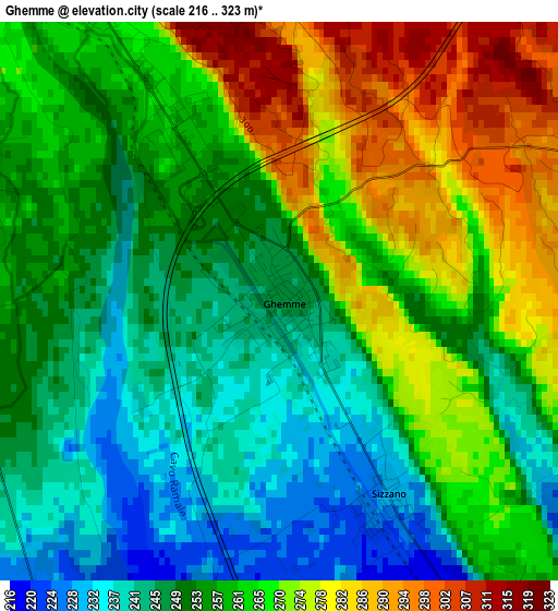
Below is the Elevation map of Ghemme, which displays elevation range with different colors. Scale of the first map is from 216 to 323 m (709 to 1060 ft) with average elevation of 259.2 meters (=850 ft) [note 1]
These maps also provides idea of topography and contour of this city, they are displayed at different zoom levels. More info about maps, scale and edge coordinates you can find below images.
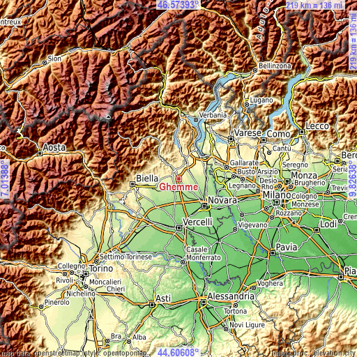
| \ | Map #1 | Topo.Map |
| Scale [m] | 216..323 m | × |
| Scale [ft] | 709..1060 ft | × |
| Average | 259.2 m = 850 ft | × |
| Width | 6.84 km = 4.3 mi | 218.8 km = 136 mi |
| Height | 6.84 km = 4.3 mi | 218.8 km = 136 mi |
| ↑Max Latitude | 45.629369° | 46.57393° |
| Latitude at center | 45.59863° | 45.59863° |
| ↓Min Latitude | 45.567874° | 44.60608° |
| ← Min Longitude | 8.376185° | 7.01388° |
| Longitude center | 8.42013° | 8.42013° |
| →Max Longitude | 8.464075° | 9.82638° |
Nearby cities:
Cities around Ghemme sort by population:
• Gattinara elevation 264 m
4.6 km,  290°
290°
• Romagnano Sesia 273 m
4.6 km,  325°
325°
• Carpignano Sesia 202 m
7.3 km,  181°
181°
• Fara Novarese 210 m
5.7 km,  149°
149°
• Prato Sesia 285 m
6.9 km, 327°
• Sizzano 229 m
2.7 km, 153°
• Cavaglio D'Agogna 245 m
5.4 km,  72°
72°
• Fontaneto D'Agogna 265 m
6.8 km,  42°
42°
• Cavallirio 363 m
7.3 km,  345°
345°
• Lenta 224 m
5.4 km,  211°
211°
• Barengo 218 m
7.7 km,  109°
109°
• Cavaglietto 237 m
6.4 km,  86°
86°
Multilingual:
 En español:
Ghemme elevación 245 m.
 En France:
Ghemme élévation 245 m.


Sources and notes:
- [note 1] Map square and city borders are not equal. Map elevation data is calculated only from area inside that square.
- [src 1] Elevation data from geonames database provided with same terms of usage.
- [src 2] The elevation map of Ghemme is generated using elevation data from NASA's 3 arcsec (90m) resolution SRTM data.
- [src 3] Base (background) map © OpenStreetMap contributors tiles are generated by Geofabrik and OpenTopoMap.
Copyright & License:
This Ghemme Elevation Map is licensed under CC BY-SA. You may reuse any part from this page, if you give a proper credit by linking to this URL:
 More info on terms of use page.