Grassano elevation
Grassano (Basilicate, Provincia di Matera), Italy elevation is 561 meters and Grassano elevation in feet is 1841 ft above sea level [src 1]. Grassano is a seat of a third-order administrative division (feature code) with elevation that is 239 meters (784 ft) bigger than average city elevation in Italy.
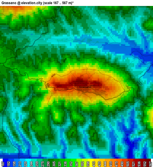
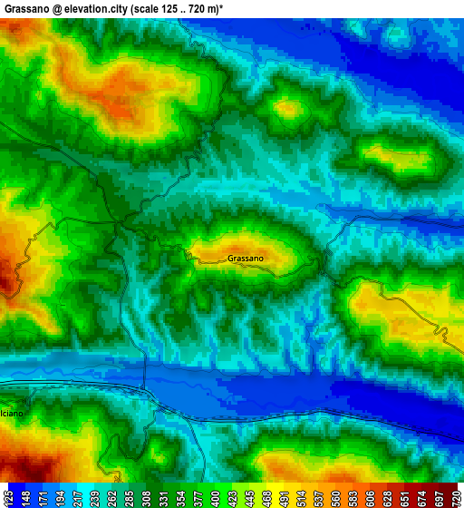
Below is the Elevation map of Grassano, which displays elevation range with different colors. Scale of the first map is from 167 to 567 m (548 to 1860 ft) with average elevation of 296.2 meters (=972 ft) [note 1]
These maps also provides idea of topography and contour of this city, they are displayed at different zoom levels. More info about maps, scale and edge coordinates you can find below images.
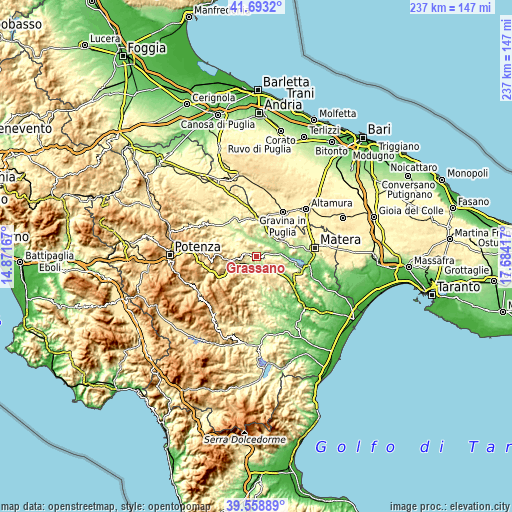
| \ | Map #1 | Map #2 | Topo.Map |
| Scale [m] | 167..567 m | 125..720 m | × |
| Scale [ft] | 548..1860 ft | 410..2362 ft | × |
| Average | 296.2 m = 972 ft | 315.3 m = 1034 ft | × |
| Width | 7.42 km = 4.6 mi | 14.83 km = 9.2 mi | 237.3 km = 147.5 mi |
| Height | 7.42 km = 4.6 mi | 14.83 km = 9.2 mi | 237.3 km = 147.5 mi |
| ↑Max Latitude | 40.667911° | 40.701235° | 41.6932° |
| Latitude at center | 40.63457° | 40.63457° | 40.63457° |
| ↓Min Latitude | 40.601213° | 40.567838° | 39.55889° |
| ← Min Longitude | 16.233975° | 16.190029° | 14.87167° |
| Longitude center | 16.27792° | 16.27792° | 16.27792° |
| →Max Longitude | 16.321865° | 16.365811° | 17.68417° |
Nearby cities:
Cities around Grassano sort by population:
• Irsina elevation 547 m
13.3 km,  345°
345°
• Tricarico 711 m
11.6 km,  258°
258°
• Salandra 542 m
12.5 km,  163°
163°
• Miglionico 450 m
20.1 km,  111°
111°
• Grottole 443 m
9.2 km, 112°
• Accettura 785 m
18.9 km,  212°
212°
• San Mauro Forte 495 m
17 km,  187°
187°
• San Chirico Nuovo 721 m
17.5 km,  285°
285°
• Garaguso 484 m
10.4 km,  203°
203°
• Campomaggiore 784 m
18.9 km,  246°
246°
• Calciano 429 m
8.9 km,  234°
234°
• Oliveto Lucano 543 m
13.5 km,  215°
215°
Multilingual:
 En español:
Grassano elevación 561 m.
 En France:
Grassano élévation 561 m.
 Auf Deutsch:
Grassano höhe über dem Meeresspiegel ist 561 m.

Sources and notes:
- [note 1] Map square and city borders are not equal. Map elevation data is calculated only from area inside that square.
- [src 1] Elevation data from geonames database provided with same terms of usage.
- [src 2] The elevation map of Grassano is generated using elevation data from NASA's 3 arcsec (90m) resolution SRTM data.
- [src 3] Base (background) map © OpenStreetMap contributors tiles are generated by Geofabrik and OpenTopoMap.
Copyright & License:
This Grassano Elevation Map is licensed under CC BY-SA. You may reuse any part from this page, if you give a proper credit by linking to this URL:
 More info on terms of use page.