Campomaggiore elevation
Campomaggiore (Basilicate, Provincia di Potenza), Italy elevation is 784 meters and Campomaggiore elevation in feet is 2572 ft above sea level [src 1]. Campomaggiore is a seat of a third-order administrative division (feature code) with elevation that is 462 meters (1516 ft) bigger than average city elevation in Italy.
Below is the Elevation map of Campomaggiore, which displays elevation range with different colors. Scale of the first map is from 274 to 1067 m (899 to 3501 ft) with average elevation of 602.7 meters (=1977 ft) [note 1]
These maps also provides idea of topography and contour of this city, they are displayed at different zoom levels. More info about maps, scale and edge coordinates you can find below images.
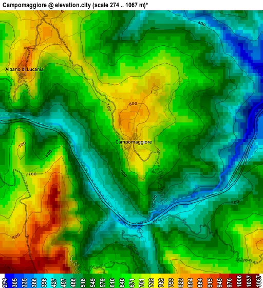
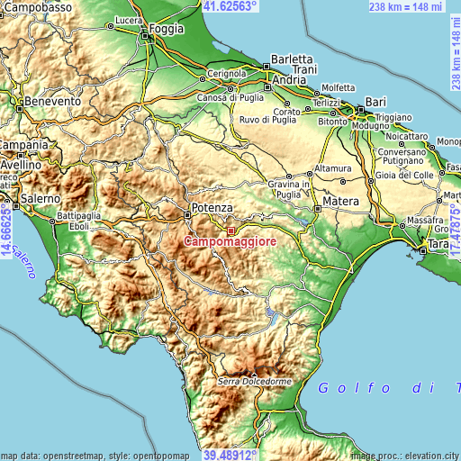
| \ | Map #1 | Topo.Map |
| Scale [m] | 274..1067 m | × |
| Scale [ft] | 899..3501 ft | × |
| Average | 602.7 m = 1977 ft | × |
| Width | 7.42 km = 4.6 mi | 237.6 km = 147.6 mi |
| Height | 7.42 km = 4.6 mi | 237.6 km = 147.6 mi |
| ↑Max Latitude | 40.599275° | 41.62563° |
| Latitude at center | 40.5659° | 40.5659° |
| ↓Min Latitude | 40.532508° | 39.48912° |
| ← Min Longitude | 16.028555° | 14.66625° |
| Longitude center | 16.0725° | 16.0725° |
| →Max Longitude | 16.116445° | 17.47875° |
Nearby cities:
Cities around Campomaggiore sort by population:
• Tricarico elevation 711 m
8 km,  47°
47°
• Accettura 785 m
11 km,  139°
139°
• San Chirico Nuovo 721 m
12.4 km,  2°
2°
• Anzi 998 m
13.6 km,  246°
246°
• Albano di Lucania 868 m
3.7 km,  306°
306°
• Pietrapertosa 949 m
5.5 km,  188°
188°
• Garaguso 484 m
13.3 km,  98°
98°
• Castelmezzano 815 m
4.7 km,  208°
208°
• Brindisi Montagna 807 m
12.2 km,  293°
293°
• Trivigno 715 m
7.3 km,  282°
282°
• Calciano 429 m
10.4 km,  76°
76°
• Oliveto Lucano 543 m
10.1 km,  109°
109°
Multilingual:
 En español:
Campomaggiore elevación 784 m.
 En France:
Campomaggiore élévation 784 m.
 Auf Deutsch:
Campomaggiore höhe über dem Meeresspiegel ist 784 m.

Sources and notes:
- [note 1] Map square and city borders are not equal. Map elevation data is calculated only from area inside that square.
- [src 1] Elevation data from geonames database provided with same terms of usage.
- [src 2] The elevation map of Campomaggiore is generated using elevation data from NASA's 3 arcsec (90m) resolution SRTM data.
- [src 3] Base (background) map © OpenStreetMap contributors tiles are generated by Geofabrik and OpenTopoMap.
Copyright & License:
This Campomaggiore Elevation Map is licensed under CC BY-SA. You may reuse any part from this page, if you give a proper credit by linking to this URL:
 More info on terms of use page.