Incisa in Val d'Arno elevation
Incisa in Val d'Arno (Tuscany, Province of Florence), Italy elevation is 123 meters and Incisa in Val d'Arno elevation in feet is 404 ft above sea level [src 1]. Incisa in Val d'Arno is a seat of a third-order administrative division (feature code) with elevation that is 199 meters (653 ft) smaller than average city elevation in Italy.
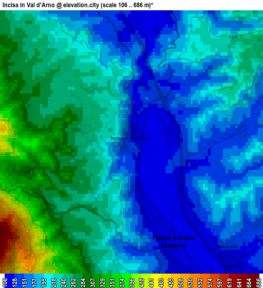
Below is the Elevation map of Incisa in Val d'Arno, which displays elevation range with different colors. Scale of the first map is from 106 to 686 m (348 to 2251 ft) with average elevation of 216.3 meters (=710 ft) [note 1]
These maps also provides idea of topography and contour of this city, they are displayed at different zoom levels. More info about maps, scale and edge coordinates you can find below images.
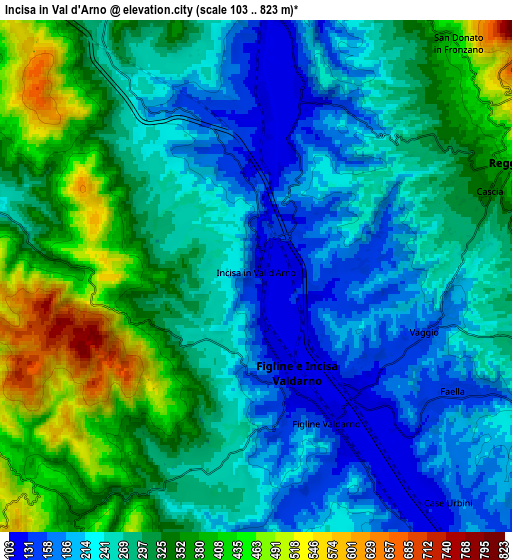
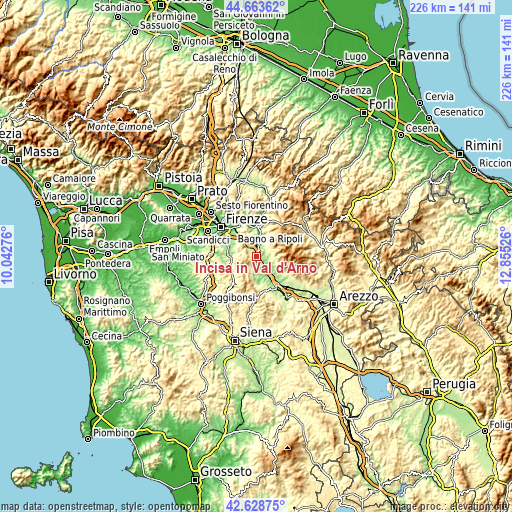
| \ | Map #1 | Map #2 | Topo.Map |
| Scale [m] | 106..686 m | 103..823 m | × |
| Scale [ft] | 348..2251 ft | 338..2700 ft | × |
| Average | 216.3 m = 710 ft | 289.7 m = 950 ft | × |
| Width | 7.07 km = 4.4 mi | 14.14 km = 8.8 mi | 226.3 km = 140.6 mi |
| Height | 7.07 km = 4.4 mi | 14.14 km = 8.8 mi | 226.2 km = 140.6 mi |
| ↑Max Latitude | 43.686587° | 43.718356° | 44.66362° |
| Latitude at center | 43.6548° | 43.6548° | 43.6548° |
| ↓Min Latitude | 43.622997° | 43.591176° | 42.62875° |
| ← Min Longitude | 11.405065° | 11.361119° | 10.04276° |
| Longitude center | 11.44901° | 11.44901° | 11.44901° |
| →Max Longitude | 11.492955° | 11.536901° | 12.85526° |
Nearby cities:
Cities around Incisa in Val d'Arno sort by population:
• San Giovanni Valdarno elevation 135 m
11.7 km,  146°
146°
• Figline Valdarno 125 m
4.3 km, 154°
• Reggello 365 m
7.1 km,  66°
66°
• Rignano sull'Arno 135 m
7.4 km,  1°
1°
• Antella 121 m
13 km,  308°
308°
• Pian di Scò 327 m
7.9 km,  100°
100°
• Strada in Chianti 239 m
12.3 km,  272°
272°
• Castelfranco di Sopra 286 m
9.6 km,  112°
112°
• Faella 149 m
6.4 km,  119°
119°
• San Cipriano-S.Barbara-Centinale 142 m
10 km,  163°
163°
• Castelnuovo dei Sabbioni 290 m
12.7 km,  178°
178°
• Vacchereccia 145 m
11.2 km, 158°
Multilingual:
 En español:
Incisa in Val d'Arno elevación 123 m.
 En France:
Incisa in Val d'Arno élévation 123 m.
 Auf Deutsch:
Incisa in Val d'Arno höhe über dem Meeresspiegel ist 123 m.
 На русском:
Incisa in Val d'Arno высота над уровнем моря 123 м
Sources and notes:
- [note 1] Map square and city borders are not equal. Map elevation data is calculated only from area inside that square.
- [src 1] Elevation data from geonames database provided with same terms of usage.
- [src 2] The elevation map of Incisa in Val d'Arno is generated using elevation data from NASA's 3 arcsec (90m) resolution SRTM data.
- [src 3] Base (background) map © OpenStreetMap contributors tiles are generated by Geofabrik and OpenTopoMap.
Copyright & License:
This Incisa in Val d'Arno Elevation Map is licensed under CC BY-SA. You may reuse any part from this page, if you give a proper credit by linking to this URL:
 More info on terms of use page.