Lemie elevation
Lemie (Piedmont, Torino), Italy elevation is 955 meters and Lemie elevation in feet is 3133 ft above sea level [src 1]. Lemie is a seat of a third-order administrative division (feature code) with elevation that is 633 meters (2077 ft) bigger than average city elevation in Italy.
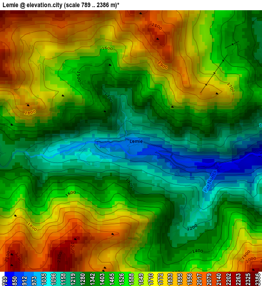
Below is the Elevation map of Lemie, which displays elevation range with different colors. Scale of the first map is from 789 to 2386 m (2589 to 7828 ft) with average elevation of 1525.4 meters (=5005 ft) [note 1]
These maps also provides idea of topography and contour of this city, they are displayed at different zoom levels. More info about maps, scale and edge coordinates you can find below images.
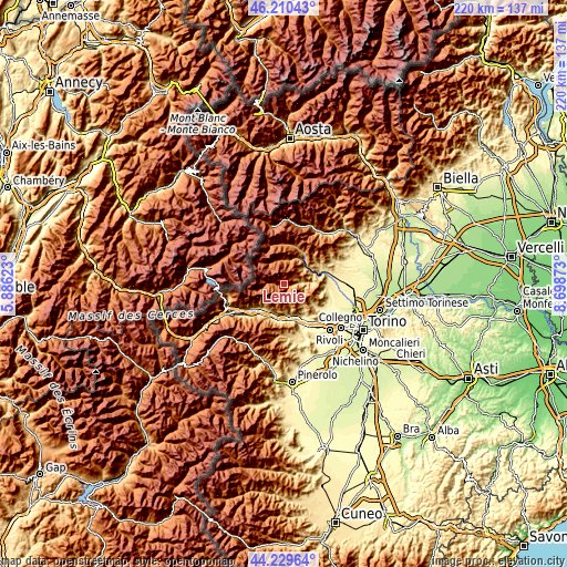
| \ | Map #1 | Topo.Map |
| Scale [m] | 789..2386 m | × |
| Scale [ft] | 2589..7828 ft | × |
| Average | 1525.4 m = 5005 ft | × |
| Width | 6.88 km = 4.3 mi | 220.2 km = 136.8 mi |
| Height | 6.88 km = 4.3 mi | 220.2 km = 136.8 mi |
| ↑Max Latitude | 45.259601° | 46.21043° |
| Latitude at center | 45.22866° | 45.22866° |
| ↓Min Latitude | 45.197702° | 44.22964° |
| ← Min Longitude | 7.248535° | 5.88623° |
| Longitude center | 7.29248° | 7.29248° |
| →Max Longitude | 7.336425° | 8.69873° |
Nearby cities:
Cities around Lemie sort by population:
• Borgone Susa elevation 402 m
12.5 km,  200°
200°
• Bruzolo 438 m
12.4 km,  218°
218°
• Mezzenile 647 m
10.9 km,  47°
47°
• Traves 614 m
11.7 km,  68°
68°
• San Didero 438 m
12.1 km,  211°
211°
• Viù 773 m
6.4 km,  80°
80°
• Pessinetto 610 m
11.6 km,  56°
56°
• Ceres 701 m
12.1 km,  38°
38°
• La Villa 628 m
11.7 km, 68°
• Ala di Stura 1071 m
9.6 km,  5°
5°
• Usseglio 1265 m
5.7 km,  274°
274°
• Balme 1425 m
10 km,  324°
324°
Multilingual:
 En español:
Lemie elevación 955 m.
 En France:
Lemie élévation 955 m.


Sources and notes:
- [note 1] Map square and city borders are not equal. Map elevation data is calculated only from area inside that square.
- [src 1] Elevation data from geonames database provided with same terms of usage.
- [src 2] The elevation map of Lemie is generated using elevation data from NASA's 3 arcsec (90m) resolution SRTM data.
- [src 3] Base (background) map © OpenStreetMap contributors tiles are generated by Geofabrik and OpenTopoMap.
Copyright & License:
This Lemie Elevation Map is licensed under CC BY-SA. You may reuse any part from this page, if you give a proper credit by linking to this URL:
 More info on terms of use page.